NASA Sees Tropical Storm Karina Get a Boost
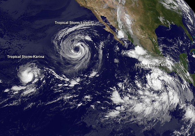
NOAA's GOES-West satellite captured Tropical Storm Karina (left), Tropical Storm Lowell (center) and Tropical Storm Marie (right) in an infrared image on Aug. 22 at 5 a.m. EDT as they moved through the Eastern Pacific Ocean. Image Credit: NASA/NOAA's GOES Project
The Tropical Rainfall Measuring Mission or TRMM satellite passed directly above the center of Tropical Storm Karina on August 22, 2014 at 0151 UTC (Aug. 21 at 9:51 p.m. EDT).
A rainfall analysis that used data from TRMM's Microwave Imager (TMI) showed that storms near Karina's center were dropping rain at a rate near 25 mm/1 inch per hour.
Where the heaviest rainfall was occurring, TRMM spotted a couple of towering thunderstorms as high as 15 km (~9 miles).
NOAA's GOES-West satellite captured Tropical Storm Karina, Tropical Storm Lowell and Tropical Storm Marie in an infrared image on Aug. 22 at 5 a.m. EDT.
Karina appeared to be in the lead of the triple tropical train of storms moving through the Eastern Pacific Ocean. The image showed how much smaller and compact Karina is in comparison to Tropical Storm Lowell.
At 11 a.m. EDT, Tropical Storm Karina's maximum sustained winds had increased to near 70 mph (110 kph), and the National Hurricane Center (NHC) noted that some fluctuations in intensity are possible before Karina begins to weaken on August 23.
The center of Tropical Storm Karina was located near latitude 15.0 north and longitude 135.6 west, about 1,325 miles (2,130 km) east of Hilo, Hawaii. Karina is moving to the northeast near 3 mph (6 kph) and is expected to turn to the east-northeast as it continues being affected by nearby Tropical Storm Lowell.
Forecaster Roberts at NHC noted that in two days Karina should be on a weakening trend because the storm will be moving into cooler waters and it will run into stable, dry air.
Text credit: Rob Gutro
NASA's Goddard Space Flight Center
Media Contact
More Information:
http://www.nasa.gov/content/goddard/karina-eastern-pacific/All latest news from the category: Earth Sciences
Earth Sciences (also referred to as Geosciences), which deals with basic issues surrounding our planet, plays a vital role in the area of energy and raw materials supply.
Earth Sciences comprises subjects such as geology, geography, geological informatics, paleontology, mineralogy, petrography, crystallography, geophysics, geodesy, glaciology, cartography, photogrammetry, meteorology and seismology, early-warning systems, earthquake research and polar research.


Newest articles

A universal framework for spatial biology
SpatialData is a freely accessible tool to unify and integrate data from different omics technologies accounting for spatial information, which can provide holistic insights into health and disease. Biological processes…

How complex biological processes arise
A $20 million grant from the U.S. National Science Foundation (NSF) will support the establishment and operation of the National Synthesis Center for Emergence in the Molecular and Cellular Sciences (NCEMS) at…

Airborne single-photon lidar system achieves high-resolution 3D imaging
Compact, low-power system opens doors for photon-efficient drone and satellite-based environmental monitoring and mapping. Researchers have developed a compact and lightweight single-photon airborne lidar system that can acquire high-resolution 3D…

