NASA sees the Tropical Cyclone Glenda away from land
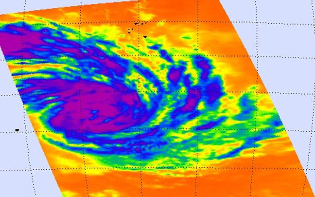
NASA's Aqua passed over Glenda on Feb. 25 at 06:47 UTC and saw strong thunderstorms with cloud top temperatures near -63F/-52C (purple) and a hint of an eye forming. Image Credit: NASA JPL, Ed Olsen
NASA's Aqua satellite passed over Glenda and the AIRS instrument aboard captured infrared data on the storm on Feb. 25 at 06:47 UTC (1:47 A.M. EST). At that time, Glenda's maximum sustained winds were near 55 knots (63.2 mph/102 kph).
The infrared data measured cloud top temperatures and found the thunderstorms surrounding the center, were high, and powerful, with cloud top temperatures near -63F/-52C.
NASA research has shown that storms with cloud tops that cold have the potential to drop heavy rain. The infrared image also showed a hint of an eye forming in the center of circulation.
On Feb. 26 at 0900 UTC (4 a.m. EST), Tropical Cyclone Glenda's maximum sustained winds remained near 55 knots (63.2 mph/102 kph), but it is expected to strengthen.
It was centered near 20.7 south latitude and 67.6 east longitude, about 586 nautical miles (674 miles/1,085 km) east of Port Louis, Mauritius, far from land. Glenda was moving to the south-southwest at 7 knots (8 mph/13 kph).
The Joint Typhoon Warning Center (JTWC) noted “Animated multispectral satellite imagery depicts thinning convection with tightly-curved banding wrapping into a partially-exposed low-level circulation center.
Although the sea surface temperatures and ocean heat content are marginal, favorable upper-level conditions are expected to persist, allowing moderate Intensification over the next 36 hours.”
Glenda is expected to gradually intensify and then turn southeast and transition into an extra-tropical storm.
Media Contact
All latest news from the category: Earth Sciences
Earth Sciences (also referred to as Geosciences), which deals with basic issues surrounding our planet, plays a vital role in the area of energy and raw materials supply.
Earth Sciences comprises subjects such as geology, geography, geological informatics, paleontology, mineralogy, petrography, crystallography, geophysics, geodesy, glaciology, cartography, photogrammetry, meteorology and seismology, early-warning systems, earthquake research and polar research.


Newest articles

Webb captures top of iconic horsehead nebula in unprecedented detail
NASA’s James Webb Space Telescope has captured the sharpest infrared images to date of a zoomed-in portion of one of the most distinctive objects in our skies, the Horsehead Nebula….

Cost-effective, high-capacity, and cyclable lithium-ion battery cathodes
Charge-recharge cycling of lithium-superrich iron oxide, a cost-effective and high-capacity cathode for new-generation lithium-ion batteries, can be greatly improved by doping with readily available mineral elements. The energy capacity and…

Novel genetic plant regeneration approach
…without the application of phytohormones. Researchers develop a novel plant regeneration approach by modulating the expression of genes that control plant cell differentiation. For ages now, plants have been the…

