NASA sees the end of ex-Tropical Cyclone 02W
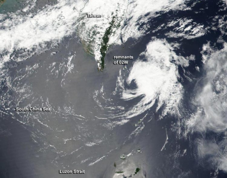
On April 20, NOAA-NASA's Suomi NPP satellite saw the remnants of Tropical Cyclone 02W as it moved through the Luzon Strait. Credits: NASA/NOAA
On April 19, 2017 at 0600 UTC (2 a.m. EST), the Joint Typhoon Warning Center noted that former Tropical Cyclone 02W was no longer suspect for tropical cyclone formation.
The low pressure area had moved into an area of strong vertical wind shear, just southeast of Taiwan and was being torn apart.
The Visible Infrared Imaging Radiometer Suite (VIIRS) instrument aboard NOAA-NASA's Suomi NPP satellite captured a visible image of the remnants after the system moved north-northeast of the northern Philippines and through the Luzon Strait.
The VIIRS image showed that strong wind shear had pushed the bulk of clouds and showers east-northeast of what was left of the center of circulation.
The strong vertical wind shear took its toll on the system and the remnants dissipated southeast of Taiwan.
###
Rob Gutro
NASA's Goddard Space Flight Center
Media Contact
All latest news from the category: Earth Sciences
Earth Sciences (also referred to as Geosciences), which deals with basic issues surrounding our planet, plays a vital role in the area of energy and raw materials supply.
Earth Sciences comprises subjects such as geology, geography, geological informatics, paleontology, mineralogy, petrography, crystallography, geophysics, geodesy, glaciology, cartography, photogrammetry, meteorology and seismology, early-warning systems, earthquake research and polar research.


Newest articles

A universal framework for spatial biology
SpatialData is a freely accessible tool to unify and integrate data from different omics technologies accounting for spatial information, which can provide holistic insights into health and disease. Biological processes…

How complex biological processes arise
A $20 million grant from the U.S. National Science Foundation (NSF) will support the establishment and operation of the National Synthesis Center for Emergence in the Molecular and Cellular Sciences (NCEMS) at…

Airborne single-photon lidar system achieves high-resolution 3D imaging
Compact, low-power system opens doors for photon-efficient drone and satellite-based environmental monitoring and mapping. Researchers have developed a compact and lightweight single-photon airborne lidar system that can acquire high-resolution 3D…

