NASA sees strong thunderstorms still surround Cyclone Iggy's center
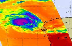
AIRS captured infrared images and cloud temperatures of Tropical Cyclone Iggy on Jan. 31 at 0623 UTC (1:23 a.m. EST). Purple areas indicate the coldest cloud tops and strongest thunderstorms. Most of the strong thunderstorms surround the center of circulation. Credit: NASA/JPL, Ed Olsen<br>
The Atmospheric Infrared Sounder Instrument called AIRS that flies aboard NASA's Aqua satellite captures infrared data and basically takes the temperature of cloud tops in tropical cyclones. That's a critical component of a tropical cyclone because the colder the cloud top, the stronger the uplift and energy in the storm.
The threshold that indicates strongest thunderstorms and highest cloud tops is -63 Fahrenheit (-52.7 Celsius) in AIRS data, and cloud tops around Iggy's center were colder than that. That means there is still a lot of strength in the storm. AIRS data also shows there are tight bands of thunderstorms that are wrapping into the center of the storm. Microwave data from NASA's Aqua satellite showed an eye in the storm, despite its status as a tropical storm.
On January 31 at 1500 UTC (10 a.m. EST) Tropical Cyclone Iggy's maximum sustained winds had decreased to 50 knots ~58 mph/~93 kph). It was located 330 nautical miles (380 miles/611 km) west-southwest of Learmonth, Australia, near 24.5 South latitude and 108.3 East longitude. It is moving to the south-southwest at 13 knots (15 mph/24 kph). The storm is just over 220 nautical miles (~253 miles/~407 km) in diameter.
Iggy has begun moving to the south-southwest, and is expected to curve back later southeast towards southwestern Australia. Current forecasts expect Iggy to weaken as it runs into strong wind shear and cooler waters. Iggy may dissipate before making landfall.
Media Contact
More Information:
http://www.nasa.govAll latest news from the category: Earth Sciences
Earth Sciences (also referred to as Geosciences), which deals with basic issues surrounding our planet, plays a vital role in the area of energy and raw materials supply.
Earth Sciences comprises subjects such as geology, geography, geological informatics, paleontology, mineralogy, petrography, crystallography, geophysics, geodesy, glaciology, cartography, photogrammetry, meteorology and seismology, early-warning systems, earthquake research and polar research.


Newest articles

A universal framework for spatial biology
SpatialData is a freely accessible tool to unify and integrate data from different omics technologies accounting for spatial information, which can provide holistic insights into health and disease. Biological processes…

How complex biological processes arise
A $20 million grant from the U.S. National Science Foundation (NSF) will support the establishment and operation of the National Synthesis Center for Emergence in the Molecular and Cellular Sciences (NCEMS) at…

Airborne single-photon lidar system achieves high-resolution 3D imaging
Compact, low-power system opens doors for photon-efficient drone and satellite-based environmental monitoring and mapping. Researchers have developed a compact and lightweight single-photon airborne lidar system that can acquire high-resolution 3D…

