NASA sees heavy rainfall in strengthening Tropical Storm Humberto
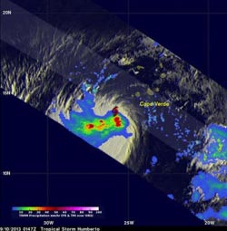
NASA's TRMM satellite showed a large area of heavy rain (red) south of Humberto's center of circulation on Sept. 9 at 9:47 p.m. EDT. A red tropical storm symbol shows Humberto's approximate center.<br><br>Credit: SSAI/NASA, Hal Pierce<br>
NASA's Tropical Rainfall Measuring Mission satellite called TRMM passed near Humberto on September 10, 2013 at 0147 UTC (9:47 p.m. Sept. 9) and collected data used in this rainfall analysis. TRMM's Microwave Imager (TMI) and Precipitation Radar (PR) showed a large area of heavy rain south of Humberto's center of circulation. Rain was falling at a rate of 2 inches/50 mm per hour.
At 11 a.m. EDT on Sept. 10, Humberto's maximum sustained winds were near 65 mph/100 kph, just 9 mph shy of hurricane-force. Humberto is now predicted by the National Hurricane Center (NHC) to become a hurricane later today, Sept. 10.
The center of Tropical Storm Humberto was located near latitude 14.6 north and longitude 27.7 west, about 220 miles/355 km west of the southernmost Cape Verde Islands. Humberto is moving toward the west-northwest near 9 mph/15 kph and is expected to turn to the northwest later today then north. The estimated minimum central pressure is 998 millibars.
If Humberto becomes a hurricane, it would be the first of the Atlantic Ocean season.
Media Contact
More Information:
http://www.nasa.govAll latest news from the category: Earth Sciences
Earth Sciences (also referred to as Geosciences), which deals with basic issues surrounding our planet, plays a vital role in the area of energy and raw materials supply.
Earth Sciences comprises subjects such as geology, geography, geological informatics, paleontology, mineralogy, petrography, crystallography, geophysics, geodesy, glaciology, cartography, photogrammetry, meteorology and seismology, early-warning systems, earthquake research and polar research.


Newest articles

A universal framework for spatial biology
SpatialData is a freely accessible tool to unify and integrate data from different omics technologies accounting for spatial information, which can provide holistic insights into health and disease. Biological processes…

How complex biological processes arise
A $20 million grant from the U.S. National Science Foundation (NSF) will support the establishment and operation of the National Synthesis Center for Emergence in the Molecular and Cellular Sciences (NCEMS) at…

Airborne single-photon lidar system achieves high-resolution 3D imaging
Compact, low-power system opens doors for photon-efficient drone and satellite-based environmental monitoring and mapping. Researchers have developed a compact and lightweight single-photon airborne lidar system that can acquire high-resolution 3D…

