NASA Sees Very Heavy Rain in Super Typhoon Jelawat and Heavy Rain Pushed from Ewinar's Center
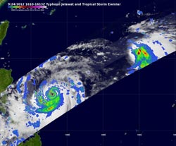
The TRMM satellite captured rainfall rates from Typhoon Jelawat and Tropical Storm Ewiniar on Sept. 24, 2012 at 1610 UTC (12:10 p.m. EDT). TRMM data showed that heaviest rainfall (purple) falling at a rate of around 80 mm/3.1 inches per hour around the tight eye of Typhoon Jelawat, while Ewiniar had small areas of moderate to heavy rainfall northeast of the center of circulation. Heavy rainfall appears in red, falling at 2 inches/50 mm per hour. Light to moderate rainfall is depicted in blue and green (falling at a rate between .78 to 1.57 inches (20 to 40 mm) per hour.<br>Credit: SSAI/NASA, Hal Pierce <br>
Super Typhoon Jelawat had super rainfall rates around its eye, while nearby Tropical Storm Ewinar's heaviest rainfall was pushed north and west of its center because of wind shear.
Jelawat was intensifying and close to a category five super typhoon when NASA's Tropical Rainfall Measuring Mission (TRMM) satellite passed above on September 24, 2012 at 1611 UTC (12:11 p.m.). A 3-D image was created using TRMM's Precipitation Radar (PR) instrument that showed hot towering thunderstorms around the tight center of circulation.
TRMM data showed that heaviest rainfall in Super Typhoon Jelawat was falling at a rate of around 3.1 inches (80 mm) per hour around the storm's tight eye. The eyewall replacement was completed today, Sept. 26, and Jelawat's clear eye is now 25 nautical miles (28.7 miles/46.3 km) wide, 8 nautical miles (9.2 miles/14.8 km) wider than it was on Sept. 25.
On Wednesday, Sept. 26, Jelawat was located 495 nautical miles (569 miles/917 km) south-southwest of Kadena Air Base, Okinawa, Japan, and has tracked northwestward at 5 knots (5.7 mph/9.3 kmh). Jelawat is forecast to continue tracking northwest and then make a turn to the northeast on Sept. 28 when it runs into an elongated area of low pressure moving east from the Yellow Sea. That turn puts Kadena Air Base, Okinawa, Japan near the center of the forecast track from the Joint Typhoon Warning Center.
NASA's Atmospheric Infrared Sounder (AIRS) instrument that flies aboard NASA's Aqua satellite captured this infrared image of Super Typhoon Jelawat on Sept. 25 at 1:23 p.m. EDT. The clear 28 mile wide eye is seen surrounded by strong thunderstorms with very cold cloud top temperatures exceeding -63F/-52C.
East of Jelawat, Tropical Storm Ewiniar is spinning in the western North Pacific Ocean. On Sept. 24, the TRMM satellite noticed that Tropical Storm Ewiniar had small areas of moderate to heavy rainfall northeast of the center of circulation. That rainfall was falling at 2 inches (50 mm) per hour. Rainfall had become weaker during the early part of Sept. 26 as wind shear continues to batter the storm from the southwest. On Sept. 26, Ewiniar's maximum sustained winds were near 45 knots (52 mph/83.3 kmh). Ewiniar was located 485 nautical miles (558 miles/898 km) south-southeast of Yokosuka, Japan, has tracked north-northeastward at 13 knots (15 mph/24 kmh). Ewiniar is forecast to turn more northward over the next day, and then turn to the northeast.
Text credit: Rob Gutro
NASA's Goddard Space Flight Center, Greenbelt, Md.
Media Contact
All latest news from the category: Earth Sciences
Earth Sciences (also referred to as Geosciences), which deals with basic issues surrounding our planet, plays a vital role in the area of energy and raw materials supply.
Earth Sciences comprises subjects such as geology, geography, geological informatics, paleontology, mineralogy, petrography, crystallography, geophysics, geodesy, glaciology, cartography, photogrammetry, meteorology and seismology, early-warning systems, earthquake research and polar research.


Newest articles

A universal framework for spatial biology
SpatialData is a freely accessible tool to unify and integrate data from different omics technologies accounting for spatial information, which can provide holistic insights into health and disease. Biological processes…

How complex biological processes arise
A $20 million grant from the U.S. National Science Foundation (NSF) will support the establishment and operation of the National Synthesis Center for Emergence in the Molecular and Cellular Sciences (NCEMS) at…

Airborne single-photon lidar system achieves high-resolution 3D imaging
Compact, low-power system opens doors for photon-efficient drone and satellite-based environmental monitoring and mapping. Researchers have developed a compact and lightweight single-photon airborne lidar system that can acquire high-resolution 3D…

