NASA sees heavy rain in Tropical Cyclone Chan-Hom
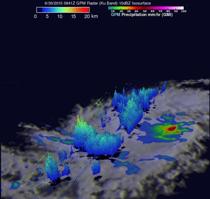
In this 3-D image using NASA/JAXA's GPM satellite, the rain was falling at a rate of over 78 mm (about 3 inches) per hour near the center of the newly formed tropical cyclone. Credits: SSAI/NASA/JAXA, Hal Pierce
The GPM core observatory satellite flew nearly above a newly formed tropical depression Chan-Hom (09W) on June 30, 2015 at 0841 (4:41 a.m. EDT). GPM's Microwave Imager (GMI) found that rain was falling at a rate of over 78 mm (about 3 inches) per hour near the center of the newly formed tropical cyclone.
GPM's Dual-Frequency Precipitation Radar (Ku Band) was able to measure rainfall to the west of Chan-Hom's center of circulation. At NASA's Goddard Space Flight Center in Greenbelt, Maryland, a 3-D image was created using GPM's Ku band radar data. The 3-D image showed storm tops reaching heights of about 15.1 km (9.3 miles) in a band of storms well to the southwest of Chan-Hom's center.
On July 1 at 0900 UTC (5 a.m. EDT), Chan-Hom was still a tropical storm with maximum sustained winds near 40 knots (46 mph/74 kph). Chan-Hom was centered near 10.8 North latitude and 155.5 East longitude, about 675 nautical miles (776 miles/ 1,250 km) east-southeast of Andersen Air Force Base. Andersen Air Force Base is located near Agafo Gumas in the U.S. territory of Guam.
Andersen Air Force Base is providing local updates about Chan-Hom's approach on their facebook page: https:/
The NWS in Tiyan, Guam issued this special weather statement on July 1: “The latest forecast brings a slowly-intensifying Chan-Hom toward the Marianas along a west to west-northwest track as it merges with a weaker circulation currently northwest of Chuuk.
Chan-Hom is expected to begin turning to the northwest and pass through the Marianas as a typhoon over the weekend. Showers and thunderstorms will develop across the Marianas Friday, July 3, and increase over the weekend. Periods of heavy rainfall are expected across the Marianas as Chan-Hom passes by. “
The Joint Typhoon Warning Center or JTWC expects Chan-hom to strengthen to a typhoon on July 2 after moving west and passing Fananu. JTWC also forecast the center of the typhoon to move very close to Guam on July 4.
Media Contact
All latest news from the category: Earth Sciences
Earth Sciences (also referred to as Geosciences), which deals with basic issues surrounding our planet, plays a vital role in the area of energy and raw materials supply.
Earth Sciences comprises subjects such as geology, geography, geological informatics, paleontology, mineralogy, petrography, crystallography, geophysics, geodesy, glaciology, cartography, photogrammetry, meteorology and seismology, early-warning systems, earthquake research and polar research.


Newest articles

Recovering phosphorus from sewage sludge ash
Chemical and heat treatment of sewage sludge can recover phosphorus in a process that could help address the problem of diminishing supplies of phosphorus ores. Valuable supplies of phosphorus could…

Efficient, sustainable and cost-effective hybrid energy storage system for modern power grids
EU project HyFlow: Over three years of research, the consortium of the EU project HyFlow has successfully developed a highly efficient, sustainable, and cost-effective hybrid energy storage system (HESS) that…

After 25 years, researchers uncover genetic cause of rare neurological disease
Some families call it a trial of faith. Others just call it a curse. The progressive neurological disease known as spinocerebellar ataxia 4 (SCA4) is a rare condition, but its…

