NASA Sees Genevieve Cross International Date Line as a Super-Typhoon
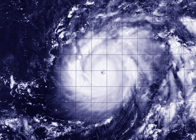
This visible image of Super-Typhoon Genevieve was taken from the VIIRS instrument aboard NASA-NOAA's Suomi NPP satellite on Aug. 7 at 1:34 UTC. Image Credit: NASA/NOAA
When Suomi NPP flew over Genevieve on August 7 at 01:48 UTC the Visible Infrared Imaging Radiometer Suite (VIIRS) instrument aboard captured an infrared image of the storm. VIIRS collects visible and infrared imagery and global observations of land, atmosphere, cryosphere and oceans. VIIRS flies aboard the Suomi NPP satellite, which is managed by both NASA and NOAA.
The VIIRS image showed a symmetrical storm with a clear eye, about 15 nautical miles (17.2 miles/27.7 km) wide, surrounded by powerful thunderstorms.
On August 7 at 1200 UTC (8 a.m. EDT) Super-Typhoon Genevieve's maximum sustained winds were near 140 knots (161.1 mph/259.3 kph). Genevieve is a Category 5 typhoon on the Saffir-Simpson Hurricane Wind Scale. Genevieve was located near latitude 15.6 north and longitude 178.1 west, approximately 692 nautical miles (796 miles/1,282 km) west of Johnston Island.
The Joint Typhoon Warning Center (JTWC) noted “Genevieve has rapidly intensified over the past 24 hours.” The storm's maximum sustained winds have increased by 75 knots (126.6 mph/ 138.9 kph), pushing the storm from 65 knots (74.3 mph/120.4 kph) to 140 knots (161.1 mph/259.3 kph).
When NASA's Tropical Rainfall Measuring Mission or TRMM satellite passed over Genevieve, data showed that there was a band of thunderstorms over the southern quadrant of the storm some 60 nautical miles (69 miles/111 km) thick.
The JTWC forecast calls for Genevieve to intensify with a peak of 145 knots (166.9 mph/268.5 kph) later on August 7. The forecast calls for Genevieve to maintain super typhoon strength over the next day and a half as it turns from a west-northwesterly track to a more northerly track over open ocean.
Text credit: Rob Gutro / Max Gleber
NASA's Goddard Space Flight Center
Media Contact
All latest news from the category: Earth Sciences
Earth Sciences (also referred to as Geosciences), which deals with basic issues surrounding our planet, plays a vital role in the area of energy and raw materials supply.
Earth Sciences comprises subjects such as geology, geography, geological informatics, paleontology, mineralogy, petrography, crystallography, geophysics, geodesy, glaciology, cartography, photogrammetry, meteorology and seismology, early-warning systems, earthquake research and polar research.


Newest articles

Organic matter on Mars was formed from atmospheric formaldehyde
Although Mars is currently a cold, dry planet, geological evidence suggests that liquid water existed there around 3 to 4 billion years ago. Where there is water, there is usually…

Engineers 3D print sturdy glass bricks for building structures
The interlocking bricks, which can be repurposed many times over, can withstand similar pressures as their concrete counterparts. What if construction materials could be put together and taken apart as…

New organic thermoelectric device
… that can harvest energy at room temperature. Researchers have succeeded in developing a framework for organic thermoelectric power generation from ambient temperature and without a temperature gradient. Researchers have…