NASA sees Alenga become a cyclone in the Southern Indian Ocean
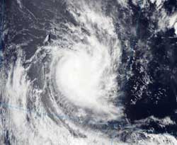
On Dec. 8 at 7:10 UTC (2:10 a.m. EST), the Moderate Resolution Imaging Spectroradiometer (MODIS) instrument aboard NASA's Aqua satellite captured a visible image of Cyclone Alenga when it passed overhead from space. Alenga appeared as a rounded area of compact clouds. Credit: NASA Goddard MODIS Rapid Response Team<br>
Alenga had grown from a tropical storm to a cyclone by 0300 UTC on Dec. 8 (10 p.m. EST, Dec. 7) when its maximum sustained winds reached 90 knots (103 mph/166 kmh).
On Dec. 8 at 7:10 UTC (2:10 a.m. EST), the Moderate Resolution Imaging Spectroradiometer (MODIS) instrument aboard NASA's Aqua satellite captured a visible image of Cyclone Alenga when it passed overhead from space. Alenga appeared as a rounded area of compact clouds. Although an eye was not apparent on visible imagery, it was seen in earlier infrared imagery. At that time, Alenga's winds had decreased as a result of wind shear.
By 1500 UTC (10 a.m. EST) on Dec. 8, Alenga's maximum sustained winds were down to 80 knots (92 mph/148 kmh). Cyclone-force winds extended 25 miles (40 km) out from the center of the storm, while tropical storm-force winds extended out to 110 miles (177 km), making the storm at least 220 miles (354 km) in diameter. Alenga was about 400 nautical miles (460 miles/740 km) south-southeast of the Cocos Islands, near 18.9 South latitude and 99.6 East longitude. It was speeding to the east-southeast near 22 knots (25 mph/40 kmh). Infrared imagery at 1500 UTC no longer showed an eye, further indication that the storm was weakening.
In addition to facing higher wind shear, a field of cold air stratocumulus clouds to the west is moving into the low level circulation of the center, and cold air also weakens tropical cyclones. Alenga is also being stretched out from the wind shear, and the strongest convection (rising air that forms the thunderstorms that make up the tropical cyclone) is now starting to stretch to the southeast of the storm's center. Alenga now faces even a third challenge: dry air. Dry air is also starting to affect the western side of the storm by absorbing moisture and eroding the band of thunderstorms.
The Joint Typhoon Warning Center expects Alenga to begin transitioning to an extra-tropical storm later today. As it begins that transition, however, the cold and dry air and the increased wind shear will work in tandem with the cooler sea surface temperatures that lay ahead in Alenga's path to cause the storm to weaken quickly.
images: http://www.nasa.gov/mission_pages/hurricanes/archives/2011/h2011_Alenga.html
Media Contact
More Information:
http://www.nasa.govAll latest news from the category: Earth Sciences
Earth Sciences (also referred to as Geosciences), which deals with basic issues surrounding our planet, plays a vital role in the area of energy and raw materials supply.
Earth Sciences comprises subjects such as geology, geography, geological informatics, paleontology, mineralogy, petrography, crystallography, geophysics, geodesy, glaciology, cartography, photogrammetry, meteorology and seismology, early-warning systems, earthquake research and polar research.


Newest articles

A universal framework for spatial biology
SpatialData is a freely accessible tool to unify and integrate data from different omics technologies accounting for spatial information, which can provide holistic insights into health and disease. Biological processes…

How complex biological processes arise
A $20 million grant from the U.S. National Science Foundation (NSF) will support the establishment and operation of the National Synthesis Center for Emergence in the Molecular and Cellular Sciences (NCEMS) at…

Airborne single-photon lidar system achieves high-resolution 3D imaging
Compact, low-power system opens doors for photon-efficient drone and satellite-based environmental monitoring and mapping. Researchers have developed a compact and lightweight single-photon airborne lidar system that can acquire high-resolution 3D…

