NASA Sees a Strengthening Tropical Cyclone Mahasen
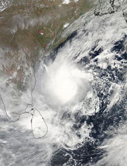
NASA’s Aqua satellite captured this visible image of a well-rounded Tropical Cyclone Mahasen in the Northern Indian Ocean on May 15 at 07:55 UTC (3:55 a.m. EDT). Mahasen is northeast of Sri Lanka and moving northward. Credit: NASA Goddard MODIS Rapid Response Team<br>
The Moderate Resolution Imaging Spectroradiometer (MODIS) instrument aboard NASA’s Aqua satellite captured a visible image of Tropical Cyclone Mahasen in the Northern Indian Ocean on May 15 at 07:55 UTC (3:55 a.m. EDT).
The image was created by NASA’s MODIS Rapid Response Team at NASA’s Goddard Space Flight Center in Greenbelt, Maryland and showed Mahasen had consolidated over the last two days. Mahasen appeared rounded and its strongest thunderstorms appeared to be surrounding the center of circulation. The center also appears to be topped with a large dense overcast. The image showed Mahasen’s center was northeast of Sri Lanka, although a band of strong thunderstorms south of the storm’s center were affecting the island nation at the time of the image.
On Monday, May 13 at 0900 UTC (5 a.m. EDT) Mahasen had maximum sustained winds near 50 knots (57.5 mph/92.6 kph). Those winds are expected to increase of the next couple of days. Mahasen was centered near 12.1 north latitude and 86.3 east longitude in the Bay of Bengal, and about 660 nautical miles (759.5 miles/ 1,222 km) south of Kolkata, India. Mahasen is moving to the northwest at 4 knots (4.6 mph/7.4 kph), but is expected to move in a more northerly direction as a result of interaction with a mid-latitude trough (elongated area) of low pressure moving in from the west.
The storm is expected to reach hurricane force by May 15 as it curves northwest. The current forecast track from the Joint Typhoon Warning Center takes the center of Mahasen just north of Chittagong early on May 17 and into northern Burma. Residents in Bangladesh and Burma should begin making preparations for storm surge, heavy rain and strong winds.
Text Credit: Rob Gutro
NASA's Goddard Space Flight Center, Greenbelt, Md.
Media Contact
All latest news from the category: Earth Sciences
Earth Sciences (also referred to as Geosciences), which deals with basic issues surrounding our planet, plays a vital role in the area of energy and raw materials supply.
Earth Sciences comprises subjects such as geology, geography, geological informatics, paleontology, mineralogy, petrography, crystallography, geophysics, geodesy, glaciology, cartography, photogrammetry, meteorology and seismology, early-warning systems, earthquake research and polar research.


Newest articles

A universal framework for spatial biology
SpatialData is a freely accessible tool to unify and integrate data from different omics technologies accounting for spatial information, which can provide holistic insights into health and disease. Biological processes…

How complex biological processes arise
A $20 million grant from the U.S. National Science Foundation (NSF) will support the establishment and operation of the National Synthesis Center for Emergence in the Molecular and Cellular Sciences (NCEMS) at…

Airborne single-photon lidar system achieves high-resolution 3D imaging
Compact, low-power system opens doors for photon-efficient drone and satellite-based environmental monitoring and mapping. Researchers have developed a compact and lightweight single-photon airborne lidar system that can acquire high-resolution 3D…

