NASA satellite spots tornado track near Conway, Ark.
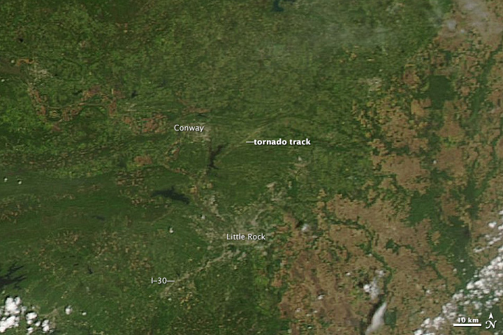
The top image, acquired on April 28 by the Moderate Resolution Imaging Spectroradiometer (MODIS) on NASA’s Aqua satellite, shows what appears to be a tornado track north of Little Rock, Arkansas.
The lower image, from April 25, shows the same area before the storm. The tracks are pale brown trails where trees and plants have been uprooted, leaving disturbed ground.
The difference in clarity between the two images is likely due to the centering of the scene beneath the satellite. On April 25, Aqua flew more directly over the area, while on April 27, it observed the Little Rock area from a slightly offset angle.
References
National Weather Service (2014, April 28) Tornadoes/Flooding on April 27-28, 2014. Accessed April 28, 2011.
Arkansas Blog (2014, April 28) Mapping the tornado’s path. Accessed April 28, 2011.
NASA image by Jeff Schmaltz, LANCE/EOSDIS Rapid Response. Caption by Adam Voiland. NASA Earth Observatory would like to credit Aaron Perry for pointing out the track.
- Instrument(s): Aqua – MODIS
Media Contact
All latest news from the category: Earth Sciences
Earth Sciences (also referred to as Geosciences), which deals with basic issues surrounding our planet, plays a vital role in the area of energy and raw materials supply.
Earth Sciences comprises subjects such as geology, geography, geological informatics, paleontology, mineralogy, petrography, crystallography, geophysics, geodesy, glaciology, cartography, photogrammetry, meteorology and seismology, early-warning systems, earthquake research and polar research.


Newest articles

A universal framework for spatial biology
SpatialData is a freely accessible tool to unify and integrate data from different omics technologies accounting for spatial information, which can provide holistic insights into health and disease. Biological processes…

How complex biological processes arise
A $20 million grant from the U.S. National Science Foundation (NSF) will support the establishment and operation of the National Synthesis Center for Emergence in the Molecular and Cellular Sciences (NCEMS) at…

Airborne single-photon lidar system achieves high-resolution 3D imaging
Compact, low-power system opens doors for photon-efficient drone and satellite-based environmental monitoring and mapping. Researchers have developed a compact and lightweight single-photon airborne lidar system that can acquire high-resolution 3D…

