NASA's TRMM Satellite Sees Hurricane Odile Strike Baja California

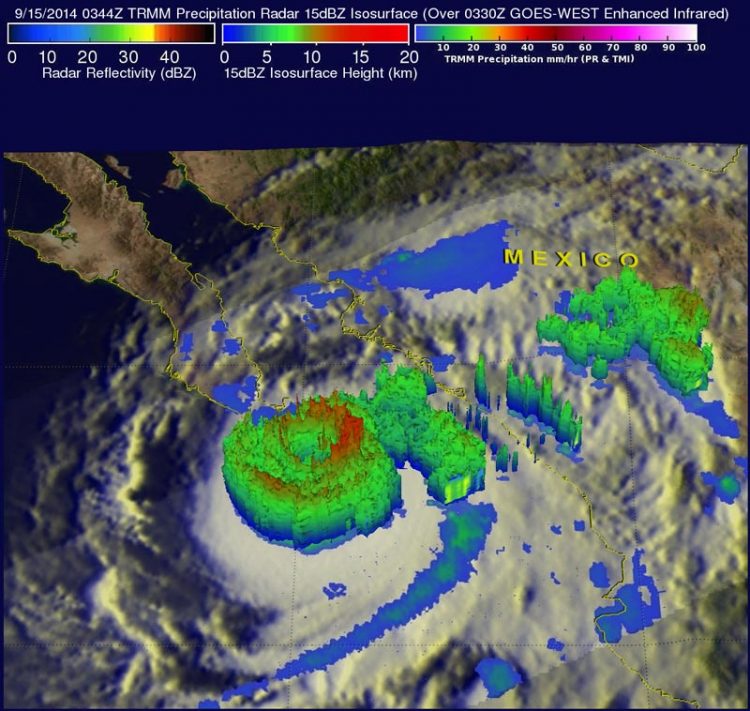
NASA's TRMM Satellite measured rainfall in Odile on Sept. 15. Odile contained intense thunderstorms around the eye above 12.5 km (about 7.8 miles) high dropping rain at a rate of over 188.4 mm (about 7.4 inches) per hour. Image Credit: NASA/SSAI, Hal Pierce
Odile made landfall near Cabo San Lucas at 0445 UTC (12:45 a.m. EDT) and was moving northwest along the length of the peninsula of Baja California, then northeast to the northern end of the Sea of Cortez.
TRMM passed directly above hurricane Odile on September 15, 2014 at 0344 UTC (Sept. 14 at 1:44 p.m. EDT). That was about an hour before the strong hurricane hit Baja California near Cabo San Lucas.
Youtube Override: NASA's TRMM Satellite measured rainfall in Odile on Sept. 15. Odile contained intense thunderstorms around the eye above 12.5 km (about 7.8 miles) high dropping rain at a rate of over 188.4 mm (about 7.4 inches) per hour. Image Credit: NASA/SSAI, Hal Pierce
Youtube Override: This animation of NOAA's GOES-West satellite imagery from September 13 through September 15 shows Hurricane Odile's movement and landfall near Cabo San Lucas on Mexico's Baja California. TRT 0:42 Image Credit: NASA/NOAA GOES Project
The National Hurricane Center (NHC) hurricane discussion on September 15, 2014 said, “The estimated intensity of 110 knots at landfall ties Odile with Olivia (1967) as the strongest hurricane to make landfall in the satellite era in the state of Baja California Sur.”
TRMM's Precipitation Radar (PR showed that Odile contained intense thunderstorms dropping rain at a rate of over 188.4 mm (about 7.4 inches) per hour in the hurricane's nearly circular eye wall.
One of the TRMM satellites most useful features has been its ability to provide vertical profiles of the rain and snow from the surface up to a height of about 12 miles (20 kilometers). At NASA's Goddard Space Flight Center in Greenbelt, Maryland a simulated 3-D view of Hurricane Odile's rainfall structure was created using the satellite's radar reflectivity data. This view showed that the tops of many intense thunderstorms in Odile's eye wall were reaching heights above 12.5 km (about 7.8 miles).
By 2 p.m. EDT on September 15, Hurricane Odile's wind speeds decreased to about 90 mph (150 kph) after hitting land and winds are forecast by the NHC to slowly decrease to below hurricane force tomorrow. Odile is moving to the northwest at 13 mph (20 kph). It was centered near 25.1 north and 111.6 west, about 45 miles (70 km) east-northeast of Cabo San Lazaro, Mexico.
Torrential rainfall is predicted to continue near the weakening system. Flash floods and landslides with rainfall totals of over 152-305 mm (6-12 inches) are predicted by the NHC as Odile travels over the Baja California Peninsula. Western Mexico is expected to feel the effects of Hurricane Odile today and tomorrow as the hurricane continues to hug the coast. A Hurricane Warning is in effect for Baja California Sur from Punta Abreojos to Santa Rosalia. A Hurricane Watch remains in effect for the west coast of Baja California Sur from north of Punta Abreojos to Punta Eugenia. A Tropical Storm Warning is in effect for the East Coast of the Baja Peninsula from north of Santa Rosalia to Bahia De Los Angeles, the west coast of the Baja Peninsula from north of Punta Eugenia to San Jose De Las Palomas and mainland Mexico from Altata to Bahia Kino.
A Tropical Storm Watch is in effect for the west coast of The Baja Peninsula North of San Jose De Las Palomas to Cabo San Quintin, the east coast of the Baja Peninsula From North of Bahia De Los Angeles to San Felipe and mainland Mexico from north of Bahia Kino to Puerto Libertad.
Although Odile continues to weaken heavy rainfall and flooding pose serious threats.
Hal Pierce / Rob Gutro
NASA's Goddard Space Flight Center
Media Contact
More Information:
http://www.nasa.gov/content/goddard/odile-eastern-pacific/All latest news from the category: Earth Sciences
Earth Sciences (also referred to as Geosciences), which deals with basic issues surrounding our planet, plays a vital role in the area of energy and raw materials supply.
Earth Sciences comprises subjects such as geology, geography, geological informatics, paleontology, mineralogy, petrography, crystallography, geophysics, geodesy, glaciology, cartography, photogrammetry, meteorology and seismology, early-warning systems, earthquake research and polar research.
Newest articles

A universal framework for spatial biology
SpatialData is a freely accessible tool to unify and integrate data from different omics technologies accounting for spatial information, which can provide holistic insights into health and disease. Biological processes…

How complex biological processes arise
A $20 million grant from the U.S. National Science Foundation (NSF) will support the establishment and operation of the National Synthesis Center for Emergence in the Molecular and Cellular Sciences (NCEMS) at…

Airborne single-photon lidar system achieves high-resolution 3D imaging
Compact, low-power system opens doors for photon-efficient drone and satellite-based environmental monitoring and mapping. Researchers have developed a compact and lightweight single-photon airborne lidar system that can acquire high-resolution 3D…


