NASA looks at winds, cloud extent of Patricia's remnant hybrid system
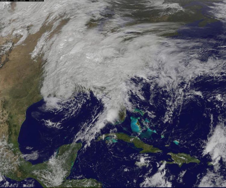
This visible image from NOAA's GOES-East satellite on Oct. 27 at 12:30 p.m. EDT shows clouds associated with the low pressure system stretch from Florida west to Louisiana and over the Mississippi and Tennessee Valleys north to the Mid-Atlantic States. Credits: NASA/NOAA GOES Project
Patricia's remnants merged with an upper-level low pressure area after it made landfall, and that system has plagued the U.S. Gulf coast states with heavy rains and gusty winds since Sunday, Oct. 25.
NASA's RapidScat instrument flies aboard the International Space Station and can detect the speed and direction of surface winds over open waters. “On October 26 at 1500 UTC (11 a.m. EDT) RapidScat got another view of the Gulf of Mexico which showed moderately high winds over a very broad area as well as a low pressure area centered over Louisiana,” said Doug Tyler of the RapidScat team at NASA's Jet Propulsion Laboratory, Pasadena, California.
RapidScat saw a small area of strongest winds over the Gulf of Mexico, just south of the Florida Panhandle at 27 meters per second (60.4 mph/97.2 kph). Near the center of the low pressure area, RapidScat measured a large area of sustained winds near 18 meters per second (40 mph/64 kph) over the Gulf of Mexico, and just south of Louisiana.
On October 27, the National Weather Service discussion said “The area of low pressure that brought heavy rain to the Gulf Coast will begin moving northward on Tuesday, bringing rain to the Ohio Valley and Appalachians before moving toward the Northeast on Wednesday. Rainfall amounts will generally be less than those across the southern Plains and Gulf Coast over the past few days.”
A visible image of the clouds associated with Patricia-hybrid system were seen in a visible image from NOAA's GOES-East satellite on October 27, 2015 at 1630 UTC (12:30 p.m. EDT). Clouds associated with the system stretch from Florida west to Louisiana and over the Mississippi and Tennessee Valleys north to the Mid-Atlantic States. NOAA manages the GOES series of satellites, and NASA/NOAA's GOES Project at NASA's Goddard Space Flight Center in Greenbelt, Maryland creates images and animations using the satellite data.
At 10 a.m. EDT the surface low with a central pressure of 1006 millibars was located about 60 miles northwest of New Orleans, Louisiana. The National Weather Service explained that an occluded front extended from the low pressure center and was moving north through southern Mississippi and Alabama. Also, there was a cold front extending from the east-central Gulf of Mexico and a quasi-stationary frontal boundary that stretched across the Alabama/Florida border and Georgia/Florida border and into the western Atlantic Ocean
The GOES image showed the clouds associated with the tropical moisture that continued to stream into the southeastern states ahead of an upper level system located in the Deep South. For forecast updates, visit the National Weather Service: http://www.
Media Contact
All latest news from the category: Earth Sciences
Earth Sciences (also referred to as Geosciences), which deals with basic issues surrounding our planet, plays a vital role in the area of energy and raw materials supply.
Earth Sciences comprises subjects such as geology, geography, geological informatics, paleontology, mineralogy, petrography, crystallography, geophysics, geodesy, glaciology, cartography, photogrammetry, meteorology and seismology, early-warning systems, earthquake research and polar research.


Newest articles

A universal framework for spatial biology
SpatialData is a freely accessible tool to unify and integrate data from different omics technologies accounting for spatial information, which can provide holistic insights into health and disease. Biological processes…

How complex biological processes arise
A $20 million grant from the U.S. National Science Foundation (NSF) will support the establishment and operation of the National Synthesis Center for Emergence in the Molecular and Cellular Sciences (NCEMS) at…

Airborne single-photon lidar system achieves high-resolution 3D imaging
Compact, low-power system opens doors for photon-efficient drone and satellite-based environmental monitoring and mapping. Researchers have developed a compact and lightweight single-photon airborne lidar system that can acquire high-resolution 3D…

