NASA analyzes rainfall in Tropical Cyclone Joalane
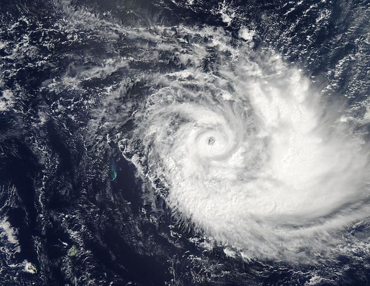
On April 8 at 09:35 UTC (5:35 a.m. EDT) NASA's Aqua satellite captured this visible light image of Tropical Cyclone Joalane that showed the storm maintained its eye. Credit: NASA Goddard MODIS Rapid Response Team
The Global Precipitation Measurement or GPM core observatory satellite flew over intensifying cyclone Joalane in the South Indian Ocean on April 6, 2015 at 0406 UTC (12:06 a.m. EDT). GPM's Microwave Imager (GMI) found that intense convective thunderstorms within Joalane were dropping rain at a rate of over 63 mm (2.5 inches) per hour.
Cyclone Joalane was located northeast of Mauritius at the time of that GPM pass. At NASA's Goddard Space Flight Center in Greenbelt, Maryland a 3-D view of Joalane's vertical precipitation structure was constructed using GPM's Radar (Ku Band) data.
This cross section showed that several towering thunderstorms near Joalane's center were reaching heights of over 15 km (9.3 miles). A few storm tops in a strong rain band south of Joalane's center were found reaching even higher to altitudes of 17.4 km (10.8 miles).
Two days later, on April 8 at 09:35 UTC (5:35 a.m. EDT) the MODIS instrument that flies aboard NASA's Aqua satellite captured a visible light image of Tropical Cyclone Joalane that showed the storm maintained an eye that it developed the previous day. Bands of thunderstorms wrapped into the center of circulation. The largest, thickest band of thunderstorms appeared on the eastern side of the center.
At 1500 UTC (11 a.m. EDT) on April 8, 2015, Tropical Cyclone Joalane's maximum sustained winds were near 90 knots (103.5 mph/166.7 kph). It was centered near 15.6 south and 64.9 east, about 624 nautical miles (718.1 miles/1,156 km) east-northeast of St. Denis.
Joalane is moving to the southeast at 9 knots (10.3 mph/16.6 kph). At that time, there were no tropical cyclone warnings in effect for Rodrigues Island.
Tropical Cyclone Joalane has intensified and the Joint Typhoon Warning Center forecast a southeastern track through the Southern Indian Ocean. Joalane is expected to weaken to a tropical storm by April 13.
Media Contact
All latest news from the category: Earth Sciences
Earth Sciences (also referred to as Geosciences), which deals with basic issues surrounding our planet, plays a vital role in the area of energy and raw materials supply.
Earth Sciences comprises subjects such as geology, geography, geological informatics, paleontology, mineralogy, petrography, crystallography, geophysics, geodesy, glaciology, cartography, photogrammetry, meteorology and seismology, early-warning systems, earthquake research and polar research.


Newest articles

A universal framework for spatial biology
SpatialData is a freely accessible tool to unify and integrate data from different omics technologies accounting for spatial information, which can provide holistic insights into health and disease. Biological processes…

How complex biological processes arise
A $20 million grant from the U.S. National Science Foundation (NSF) will support the establishment and operation of the National Synthesis Center for Emergence in the Molecular and Cellular Sciences (NCEMS) at…

Airborne single-photon lidar system achieves high-resolution 3D imaging
Compact, low-power system opens doors for photon-efficient drone and satellite-based environmental monitoring and mapping. Researchers have developed a compact and lightweight single-photon airborne lidar system that can acquire high-resolution 3D…

