NASA's TRMM Sees Heavy Rain Over Taiwan from Tropical Storm Kong-Rey
The TRMM satellite measured Tropical Storm Kong-Rey's rainfall at a rate of over 205mm/8 inches per hour in intense bands of rain over southwestern Taiwan on August 28. Kong-Rey's location is shown with a red symbol. <br><br>Image Credit: SSAI/NASA, Hal Pierce<br>
Flooding from torrential rainfall with totals of over 500 mm (~19.7 inches) have been reported in western Taiwan.
A rainfall analysis from TRMM's Microwave Imager (TMI) and Precipitation Radar (PR) instruments revealed that precipitation was falling was at a rate of over 205mm/8 inches per hour in intense bands of rain over southwestern Taiwan.
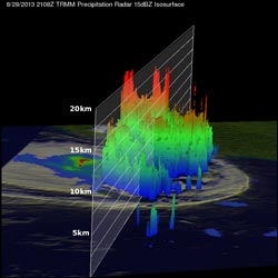
TRMM data was used to create a 3-D image looking from the east, showed the extremely high storms located on the western side of Taiwan.
TRMM showed that the tops of those powerful thunderstorms were often reaching heights above 16.5 km (~10.3 miles).
On Aug. 30 at 1500 UTC/11 a.m. EDT, Kong-Rey had weakened to a tropical depression with maximum sustained winds near 30 knots/34.5 mph/55.5 kph. It had passed Taiwan and was centered near 31.7 north and 126.6 east, about 251 nautical miles/288 miles/465 km west-southwest of Sasebo, Japan. Kong-Rey was moving northeastward at 13 knots/15 mph/20.9 kph.
Tropical Depression Kong-Rey is now predicted to move to the north then northeast and remain just off the western coast of Japan until it makes a brief landfall near Misawa in the north on Sept. 1. Resident along western Japan can expect showers, gusty winds and rough surf over the next several days.
Text credit: Rob Gutro
NASA's Goddard Space Flight Center
Media Contact
All latest news from the category: Earth Sciences
Earth Sciences (also referred to as Geosciences), which deals with basic issues surrounding our planet, plays a vital role in the area of energy and raw materials supply.
Earth Sciences comprises subjects such as geology, geography, geological informatics, paleontology, mineralogy, petrography, crystallography, geophysics, geodesy, glaciology, cartography, photogrammetry, meteorology and seismology, early-warning systems, earthquake research and polar research.


Newest articles

A universal framework for spatial biology
SpatialData is a freely accessible tool to unify and integrate data from different omics technologies accounting for spatial information, which can provide holistic insights into health and disease. Biological processes…

How complex biological processes arise
A $20 million grant from the U.S. National Science Foundation (NSF) will support the establishment and operation of the National Synthesis Center for Emergence in the Molecular and Cellular Sciences (NCEMS) at…

Airborne single-photon lidar system achieves high-resolution 3D imaging
Compact, low-power system opens doors for photon-efficient drone and satellite-based environmental monitoring and mapping. Researchers have developed a compact and lightweight single-photon airborne lidar system that can acquire high-resolution 3D…

