Exploring the deep: drones offer new ways to monitor sea floor
Researchers led by the Institute of Industrial Science, The University of Tokyo develop a novel method for measuring seafloor movement
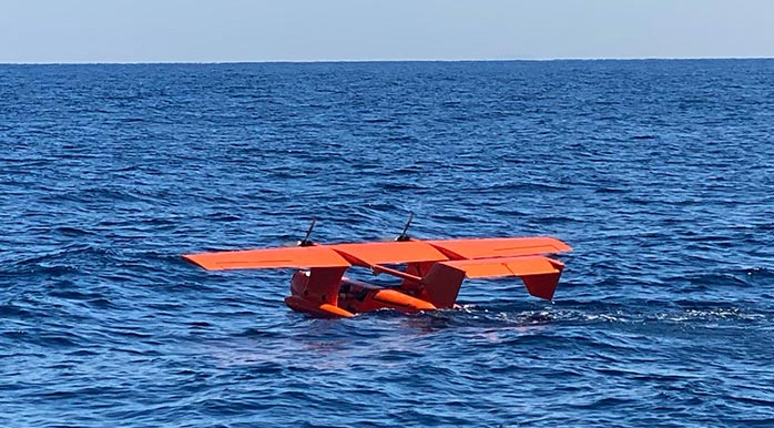
Credit: Institute of Industrial Science, The University of Tokyo
Measuring the position and topography of the earth’s crust is critical for understanding earthquake risk. Now, researchers led by the Institute of Industrial Science, The University of Tokyo have developed a novel method for monitoring the position of the seafloor with a drone-based observation device that could revolutionize oceanographic observation.
Changes in the earth’s surface occur as a result of tectonic forces accumulating in the crust, a process called crustal deformation. When forces that are exerted on the crust (stress) from the movement of tectonic plates exceed the strength of the rock, they can change its shape. Measuring these changes (geodetic measurements) can reveal the underlying tectonic processes and provide insights into seismic risk. However, approximately 70% of the earth’s surface lies underwater, presenting a unique set of challenges for monitoring.
“Measurement of the seafloor has traditionally been conducted using buoys or ocean-going vessels,” explains co-author Professor Yokota. “Seafloor stations need to communicate with vessels or buoys at the surface that, in turn, communicate with satellites to produce accurate positional information. But ocean conditions limit the mobility and speed of vessels at the surface.”
To address some of these challenges, the team developed a sea-surface landing unmanned aerial vehicle (UAV) as a sea surface monitoring device. A lightweight measurement device was mounted on the UAV, which moves over the sea surface and communicates with seafloor observation stations. The advantages of this system are the speed and efficiency of obtaining deep seafloor information.
“The mobility of this UAV means it’s possible to acquire deep geodetic measurements much more quickly and efficiently than before,” says co-author Professor Hirakawa. “Such high-speed UAV observation in the sea will not only contribute toward disaster prevention but also aid in the operation of autonomous underwater vehicles/remotely operated vehicles, and enable frequent marine biological and fisheries science observations.”
Next steps for the team include additional testing of the UAV at sea and further development of autonomous navigation and observation technology. Given the devastation that can be caused by earthquakes and tsunamis, accurate information that can help with prediction, such as that acquired by UAVs, is vital.
About Institute of Industrial Science, The University of Tokyo
The Institute of Industrial Science, The University of Tokyo (UTokyo-IIS) is one of the largest university-attached research institutes in Japan. UTokyo-IIS is comprised of over 120 research laboratories—each headed by a faculty member—and has over 1,200 members (approximately 400 staff and 800 students) actively engaged in education and research. Its activities cover almost all areas of engineering. Since its foundation in 1949, UTokyo-IIS has worked to bridge the huge gaps that exist between academic disciplines and real-world applications.
Media Contact
Yusuke Yokota
Institute of Industrial Science, The University of Tokyo
yyokota@iis.u-tokyo.ac.jp
Office: 81-354-526-188
Original Source
All latest news from the category: Earth Sciences
Earth Sciences (also referred to as Geosciences), which deals with basic issues surrounding our planet, plays a vital role in the area of energy and raw materials supply.
Earth Sciences comprises subjects such as geology, geography, geological informatics, paleontology, mineralogy, petrography, crystallography, geophysics, geodesy, glaciology, cartography, photogrammetry, meteorology and seismology, early-warning systems, earthquake research and polar research.


Newest articles

Faster, more energy-efficient way to manufacture an industrially important chemical
Zirconium combined with silicon nitride enhances the conversion of propane — present in natural gas — needed to create in-demand plastic, polypropylene. Polypropylene is a common type of plastic found…

Energy planning in Ghana as a role model for the world
Improving the resilience of energy systems in the Global South. What criteria should we use to better plan for resilient energy systems? How do socio-economic, technical and climate change related…

Artificial blood vessels could improve heart bypass outcomes
Artificial blood vessels could improve heart bypass outcomes. 3D-printed blood vessels, which closely mimic the properties of human veins, could transform the treatment of cardiovascular diseases. Strong, flexible, gel-like tubes…

