ASA infrared eye sees tropical cyclone Nilam soak Sri Lanka
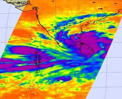
The AIRS instrument aboard NASA's Aqua satellite captured this image of Tropical Cyclone Nilam on Oct. 29 at 2029 4:29 p.m. EDT. The strongest storms with coldest cloud top temperatures appear in purple and were covering Sri Lanka. The purple indicates temperatures as cold as -63F (-52C).<br><br>Credit: Credit: NASA JPL, Ed Olsen<br>
The Atmospheric Infrared Sounder (AIRS) instrument aboard NASA's Aqua satellite captured an infrared image of Tropical Cyclone Nilam on Oct. 29 at 2029 4:29 p.m. EDT.
At the time of the AIRS image, the strongest storms with coldest cloud top temperatures were covering Sri Lanka and stretched into the open waters of the Northern Indian Ocean. Cloud top temperatures in those areas were as cold as -63F (-52C) and are indicative of heavy rainfall.
On Oct. 30 at 1200 UTC (8 a.m. EDT) Tropical Storm Nilam had maximum sustained winds near 45 knots (51.7 mph/83.3 kph). It was located about 265 nautical miles (305 miles/491 km) southeast of Chennai, India, near 9.4 North latitude and 82.9 East longitude and moving northwest at 6 knots (7 mph/11.1 kph).
Nilam's center was forecast to move over northern Sri Lanka and make landfall on Oct. 30 in Tamil Nadu, located in southern India. Tamil Nadu is located between Pondicherry to the north and Trivandrum to the south.
Media Contact
More Information:
http://www.nasa.govAll latest news from the category: Earth Sciences
Earth Sciences (also referred to as Geosciences), which deals with basic issues surrounding our planet, plays a vital role in the area of energy and raw materials supply.
Earth Sciences comprises subjects such as geology, geography, geological informatics, paleontology, mineralogy, petrography, crystallography, geophysics, geodesy, glaciology, cartography, photogrammetry, meteorology and seismology, early-warning systems, earthquake research and polar research.


Newest articles

A universal framework for spatial biology
SpatialData is a freely accessible tool to unify and integrate data from different omics technologies accounting for spatial information, which can provide holistic insights into health and disease. Biological processes…

How complex biological processes arise
A $20 million grant from the U.S. National Science Foundation (NSF) will support the establishment and operation of the National Synthesis Center for Emergence in the Molecular and Cellular Sciences (NCEMS) at…

Airborne single-photon lidar system achieves high-resolution 3D imaging
Compact, low-power system opens doors for photon-efficient drone and satellite-based environmental monitoring and mapping. Researchers have developed a compact and lightweight single-photon airborne lidar system that can acquire high-resolution 3D…

