Tropical Storm Dora bringing rough surf to southern Mexico
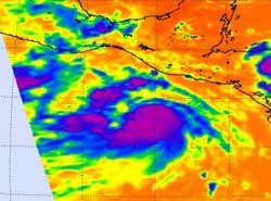
This infrared image of Tropical Storm Dora was captured from the AIRS instrument on NASA's Aqua satellite on July 18, 2011 at 1929 UTC (3:29 p.m. EDT/12:29 PDT) and it revealed a large area of very cold cloud top temperatures (purple) on strong thunderstorms surrounding the center. Credit: NASA JPL, Ed Olsen<br>
Tropical Storm Dora was just a depression yesterday. Since then, NASA satellite imagery has watched Dora continue to strengthen as thunderstorm cloud tops have grown much colder. Dora is now stirring up high seas in the eastern Pacific and beach goers in southwestern will encounter warnings because of high surf Dora is kicking up. Warnings are also posted for three western Mexican states.
Dora reached tropical storm strength at 2 p.m. EDT yesterday, July 18 and is now nearing hurricane strength. The National Hurricane Center expects Dora to strengthen into a hurricane later today.
That forecast coincides with infrared satellite imagery coming from the Atmospheric Infrared Sounder (AIRS) instrument that flies on NASA's Aqua satellite. AIRS captured an infrared image of Dora's cloud top temperatures on July 18 at 1929 UTC (3:29 p.m. EDT/12:29 PDT) and it revealed a large area of very cold cloud top temperatures on thunderstorms surrounding Dora's center.
On the morning of July 18, AIRS infrared imagery showed that the strong convection (rapidly rising air that creates the thunderstorms that power the tropical cyclone) have increased near the center of the tropical storm.
Those cloud tops were so high into the troposphere that the temperatures were as cold as -63 Fahrenheit (-52 Celsius). AIRS infrared imagery also revealed that Dora has the signature “comma” shape of a hurricane.
As a result of the power of Dora's increasing winds, large ocean swells are expected to begin affecting the southern coast of mainland Mexico today. These swells are likely to cause life-threatening surf and rip current conditions.
The Mexican Weather Service has posted weather warnings for the Mexican states of Chiapas, Oaxaca and Guerrero. Residents in those states can expect heavy rains, gusty winds, and some local flooding. According to weather reports from the National Oceanic and Atmospheric Administration, Oaxaca was already reporting rain at 9 a.m. EDT on July 19. Winds were from the east-northeast near 5 mph (4 knots) and it was 62 degrees Fahrenheit (17C). For weather advisories in Spanish from the Mexican Weather Service, go to: http://smn.cna.gob.mx/.
At 5 a.m. EDT (2 a.m. PDT), Tropical Storm Dora's winds were near 65 mph (100 kmh) and are expected to continue strengthening today. It was located about 300 miles (485 km) south of Puerto Angel, Mexico near 11.4 North and 95.9 West. It was moving to the west near 16 mph (26 kmh). Tropical storm-force winds extend out 125 miles from the center, making the storm about 250 miles in diameter.
Dora is expected to continue tracking off-shore from western Mexico and strengthen to hurricane status later today.
Media Contact
More Information:
http://www.nasa.govAll latest news from the category: Earth Sciences
Earth Sciences (also referred to as Geosciences), which deals with basic issues surrounding our planet, plays a vital role in the area of energy and raw materials supply.
Earth Sciences comprises subjects such as geology, geography, geological informatics, paleontology, mineralogy, petrography, crystallography, geophysics, geodesy, glaciology, cartography, photogrammetry, meteorology and seismology, early-warning systems, earthquake research and polar research.


Newest articles

A universal framework for spatial biology
SpatialData is a freely accessible tool to unify and integrate data from different omics technologies accounting for spatial information, which can provide holistic insights into health and disease. Biological processes…

How complex biological processes arise
A $20 million grant from the U.S. National Science Foundation (NSF) will support the establishment and operation of the National Synthesis Center for Emergence in the Molecular and Cellular Sciences (NCEMS) at…

Airborne single-photon lidar system achieves high-resolution 3D imaging
Compact, low-power system opens doors for photon-efficient drone and satellite-based environmental monitoring and mapping. Researchers have developed a compact and lightweight single-photon airborne lidar system that can acquire high-resolution 3D…

