NASA sees Tropical Depression 30W stretching out, fading
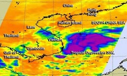
NASA's Aqua satellite passed over Tropical Depression 30W on Nov. 5 at 1:23 p.m. EST and saw that wind shear had stretched the system and the strongest thunderstorms from west to east.<br><br>Credit: NASA JPL, Ed Olsen<br>
NASA's Aqua satellite passed over Tropical Depression 30W on Nov. 5 at 18:23 UTC/1:23 p.m. EST.
The Atmospheric Infrared Sounder or AIRS instrument captured infrared data about the storm's cloud top temperatures. The AIRS data also showed wind shear had stretched the system from west to east.
On Nov. 6 Tropical Depression 30W was making landfall in southern Vietnam. At 0900 UTC/4 a.m. EST, the final warning from the Joint Typhoon Warning Center placed the center of the depression about 200 nautical miles/230.2 miles/370.4 km east-northeast of Ho Chi Minh City, Vietnam, near 10.9 north and 115.3 east.
It was moving to the west at 12 knots/13.8 mph/ 22.2 kph, and its maximum sustained winds had dropped to 25 knots/28.7 mph/ 46.3 kph.
Animated multispectral satellite imagery showed that thunderstorm development was shallow as the storm continued to stretch out.
Tropical Depression 30W is expected to dissipate over southern Vietnam in the next day, although the Joint Typhoon Warning Center noted that there is a chance of regeneration once the remnants move over the Gulf of Thailand or the Andaman Sea.
Media Contact
More Information:
http://www.nasa.govAll latest news from the category: Earth Sciences
Earth Sciences (also referred to as Geosciences), which deals with basic issues surrounding our planet, plays a vital role in the area of energy and raw materials supply.
Earth Sciences comprises subjects such as geology, geography, geological informatics, paleontology, mineralogy, petrography, crystallography, geophysics, geodesy, glaciology, cartography, photogrammetry, meteorology and seismology, early-warning systems, earthquake research and polar research.


Newest articles

A universal framework for spatial biology
SpatialData is a freely accessible tool to unify and integrate data from different omics technologies accounting for spatial information, which can provide holistic insights into health and disease. Biological processes…

How complex biological processes arise
A $20 million grant from the U.S. National Science Foundation (NSF) will support the establishment and operation of the National Synthesis Center for Emergence in the Molecular and Cellular Sciences (NCEMS) at…

Airborne single-photon lidar system achieves high-resolution 3D imaging
Compact, low-power system opens doors for photon-efficient drone and satellite-based environmental monitoring and mapping. Researchers have developed a compact and lightweight single-photon airborne lidar system that can acquire high-resolution 3D…

