NASA sees Tropical Cyclone Narelle form in Southern Indian Ocean
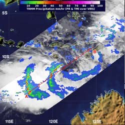
NASA's TRMM satellite passed over System 98S on Jan. 7 at 4:01 a.m. EST/US hours before it intensified into Tropical Storm Narelle. TRMM saw two bands of strong thunderstorms west and northwest of the center where heavy rainfall (red) was occurring.<br><br>Credit: NASA/SSAI, Hal Pierce<br>
NASA's TRMM satellite passed over System 98S and saw the hallmark “hot towers” that indicated the storm would soon likely intensify into Tropical Storm Narelle.
NASA's Tropical Rainfall Measuring Mission (TRMM) satellite passed over System 98S on Jan. 7 at 0901 UTC (4:01 a.m. EST/U.S.) hours before it intensified into Tropical Storm Narelle.
TRMM's Precipitation Radar instrument captured estimates of rainfall occurring in the storm. TRMM noticed two bands of strong thunderstorms west and northwest of the center of circulation where rainfall was occurring at more than 2 inches/50 mm per hour. Some of those thunderstorms were “hot towers,” or large towering thunderstorms.
A “hot tower” is a tall cumulonimbus cloud that reaches at least to the top of the troposphere, the lowest layer of the atmosphere. It extends approximately nine miles (14.5 km) high in the tropics. The hot towers in System 98S were over 9.3 miles (15 km) high. These towers are called “hot” because they rise to such altitude due to the large amount of latent heat. Water vapor releases this latent heat as it condenses into liquid. NASA research shows that a tropical cyclone with a hot tower in its eyewall was twice as likely to intensify within six or more hours, than a cyclone that lacked a hot tower. System 98S became Tropical Storm Narelle on Jan. 7 at 1800 UTC (1 p.m. EST/U.S.).
On Jan. 8, infrared satellite imagery showed that the low-level circulation center was consolidating (organizing). Just as the TRMM satellite showed improved convective (rising air that forms the thunderstorms that make up the tropical cyclone) banding in the western and northern quadrants of the storm on Jan. 7, infrared satellite data on Jan. 8 showed improved deep convective banding over the southeast quadrant of the system.
On Jan. 8 at 1500 UTC (10 a.m. EST/U.S.), Tropical cyclone Narelle had maximum sustained winds near 45 knots (51.7 mph/83.3 kph). The center of Narelle was located near 12.8 south latitude and 117.4 east longitude, about 605 miles north-northeast of Learmonth, Australia. Narelle was moving to the southwest at 9 knots (10.3 mph/16.6 kph).
Forecasters at the Joint Typhoon Warning Center (JTWC) take Narelle on a south-southwestward journey as a result of moving around the northwestern edge of a low-to-mid-level subtropical ridge (elongated area) of high pressure, located to the east and southeast of the system. That's because high pressure systems in the southern hemisphere rotate counter-clockwise.
JTWC forecasters expect that Narelle will continue to intensify and may reach wind speeds of 130 knots in three days as it nears Learmonth, Western Australia. The current forecast track, however, keeps the center at sea, but the eastern half of the storm is expected to impact the far western part of West Australia, including Learmonth. If the cyclone gets that strong, that would mean very rough seas and some coastal erosion, possible heavy rainfall and gusty winds for that area. Currently, there are no warnings in effect for Western Australia, but residents should monitor their local forecasts.
Media Contact
More Information:
http://www.nasa.govAll latest news from the category: Earth Sciences
Earth Sciences (also referred to as Geosciences), which deals with basic issues surrounding our planet, plays a vital role in the area of energy and raw materials supply.
Earth Sciences comprises subjects such as geology, geography, geological informatics, paleontology, mineralogy, petrography, crystallography, geophysics, geodesy, glaciology, cartography, photogrammetry, meteorology and seismology, early-warning systems, earthquake research and polar research.


Newest articles

High-energy-density aqueous battery based on halogen multi-electron transfer
Traditional non-aqueous lithium-ion batteries have a high energy density, but their safety is compromised due to the flammable organic electrolytes they utilize. Aqueous batteries use water as the solvent for…

First-ever combined heart pump and pig kidney transplant
…gives new hope to patient with terminal illness. Surgeons at NYU Langone Health performed the first-ever combined mechanical heart pump and gene-edited pig kidney transplant surgery in a 54-year-old woman…

Biophysics: Testing how well biomarkers work
LMU researchers have developed a method to determine how reliably target proteins can be labeled using super-resolution fluorescence microscopy. Modern microscopy techniques make it possible to examine the inner workings…

