NASA sees Tropical Cyclone Linda lose an 'arm'
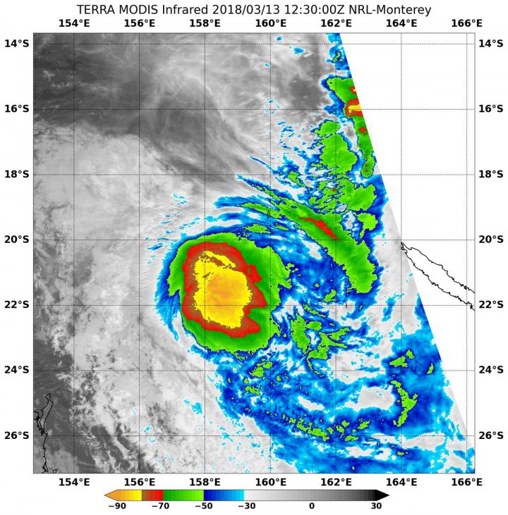
On March 13, 2018, at 8:30 a.m. EDT (1230 UTC) NASA's Terra satellite found top temperatures of strongest thunderstorms (yellow) in Tropical Cyclone Linda. Temperatures were as cold as or colder than minus 80 degrees Fahrenheit (minus 62.2 Celsius). Credit: NRL/NASA
By analyzing a storm in infrared light, scientists can tell cloud top temperatures that give clues about the location of the highest, coldest and strongest storms.
On March 12 at 11:05 p.m. EDT (March 13 at 0305 UTC), infrared data from the Atmospheric Infrared Sounder, or AIRS, instrument aboard NASA's Aqua satellite found the strongest storms in Linda. AIRS data showed powerful storms around Linda's center and in a strong band of thunderstorms east of the center.
By 8:30 a.m. EDT (1230 UTC) the Moderate Resolution Imaging Spectroradiometer, or MODIS, instrument aboard NASA's Terra satellite provided an infrared look at Tropical Storm Linda's cloud top temperatures. The MODIS image showed that the once-strong band of thunderstorms east of Linda's center had weakened and fragmented.
MODIS data also found cloud top temperatures of strongest thunderstorms were as cold as or colder than minus 80 degrees Fahrenheit (minus 62.2 Celsius) around the center of circulation. The center was located over the open waters of the South Pacific. Cloud top temperatures that cold indicate strong storms that have the capability to create heavy rain.
The Joint Typhoon Warning Center noted on March 13 at 11 a.m. EDT (1500 UTC) when the center was located near 21.1 degrees south latitude and 158.9 degrees east longitude, about 397 nautical miles west-northwest of Noumea, New Caledonia. Linda had maximum sustained winds near 46 mph (40 knots/74 kph) and it was moving to the south-southwest at 19.5 mph (17 knots/31.4 kph).
The Joint Typhoon Warning Center noted that Linda is being affected by northerly vertical wind shear, pushing clouds south of center. Linda is moving south-southwest along the western edge of subtropical ridge (an elongated area of high pressure), which is located to the east-southeast of the tropical storm.
Linda is expected to continue moving under increasing adverse conditions, so the storm is expected to dissipate by March 15.
Media Contact
More Information:
https://www.nasa.gov/feature/goddard/2018/linda-southern-pacific-oceanAll latest news from the category: Earth Sciences
Earth Sciences (also referred to as Geosciences), which deals with basic issues surrounding our planet, plays a vital role in the area of energy and raw materials supply.
Earth Sciences comprises subjects such as geology, geography, geological informatics, paleontology, mineralogy, petrography, crystallography, geophysics, geodesy, glaciology, cartography, photogrammetry, meteorology and seismology, early-warning systems, earthquake research and polar research.


Newest articles

High-energy-density aqueous battery based on halogen multi-electron transfer
Traditional non-aqueous lithium-ion batteries have a high energy density, but their safety is compromised due to the flammable organic electrolytes they utilize. Aqueous batteries use water as the solvent for…

First-ever combined heart pump and pig kidney transplant
…gives new hope to patient with terminal illness. Surgeons at NYU Langone Health performed the first-ever combined mechanical heart pump and gene-edited pig kidney transplant surgery in a 54-year-old woman…

Biophysics: Testing how well biomarkers work
LMU researchers have developed a method to determine how reliably target proteins can be labeled using super-resolution fluorescence microscopy. Modern microscopy techniques make it possible to examine the inner workings…

