NASA sees large Tropical Cyclone Yasi headed toward Queensland, Australia
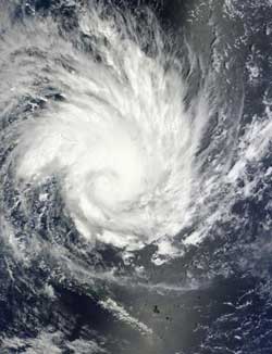
NASA\'s Terra satellite captured an image of Yasi on Jan. 30 at 23:20 UTC (6:20 p.m. EST/09:20 a.m., Monday, Jan. 31 in Australia/Brisbane local time). Although the image did not reveal a visible eye, the storm appears to be well-formed and also appears to be strengthening. Credit: NASA Goddard / MODIS Rapid Response Team<br>
The Moderate Resolution Imaging Spectroradiometer (MODIS) instrument that flies aboard NASA's Terra satellite captured an image of Cyclone Yasi on Jan. 30 at 23:20 UTC (6:20 p.m. EST/09:20 a.m., Monday, January 31 in Australia/Brisbane local time). Although the image did not reveal a visible eye, the storm appears to be well-formed and also appears to be strengthening.
Warnings and watches are already in effect throughout the Coral Sea. The Solomon Islands currently have a Tropical Cyclone warning for the provinces of Temotu, Rennell& Bellona, Makira and Guadalcanal. The Australian Bureau of Meteorology has already posted a Tropical Cyclone Watch from Cooktown to Yeppoon and inland to between Georgetown and Moranbah in Queensland, Australia. The Australian Bureau of Meteorology expects damaging winds to develop in coastal and island communities between Cooktown and Yeppoon Wednesday morning, and inland areas on Wednesday afternoon. Updates from the Australian Bureau of Meteorology can be monitored at the Bureau's website at www.bom.gov.au.
On January 31 at 1500 UTC (10 a.m. EST/ 1:00 a.m. Tuesday February 1, 2011 in Australia/Brisbane local time), Tropical Cyclone Yasi had maximum sustained winds near 90 knots (103 mph/166 kmh). Yasi is a Category Two Cyclone on the Saffir-Simpson Scale.
It was centered about 875 miles E of Cairns, Australia, near 13.4 South latitude and 160.4 East longitude. It was moving west near 19 knots (22 mph/35 kmh). Cyclone-force winds extend out to 30 miles (48 km) from the center.
Animated infrared satellite imagery, such as that from the Atmospheric Infrared Sounder (AIRS) that flies on NASA's Aqua satellite, showed deep convective (thunderstorm) bands wrapping tighter into the low level circulation center. Wrapping bands of thunderstorms indicate strengthening.
Yasi is forecast to move west then southwestward into an area of low vertical wind shear (strong wind shear can weaken a storm). Forecasters at the Joint Typhoon Warning Center (JTWC) expect Yasi to continue strengthening over the next 36 hours. JTWC forecasts a landfall just south of Cairns as a large 100-plus knot (115 mph/185 kmh)n system by Wednesday. Residents along the Queensland coast should now be making preparations now for the storm's arrival.
Media Contact
More Information:
http://www.nasa.govAll latest news from the category: Earth Sciences
Earth Sciences (also referred to as Geosciences), which deals with basic issues surrounding our planet, plays a vital role in the area of energy and raw materials supply.
Earth Sciences comprises subjects such as geology, geography, geological informatics, paleontology, mineralogy, petrography, crystallography, geophysics, geodesy, glaciology, cartography, photogrammetry, meteorology and seismology, early-warning systems, earthquake research and polar research.


Newest articles

High-energy-density aqueous battery based on halogen multi-electron transfer
Traditional non-aqueous lithium-ion batteries have a high energy density, but their safety is compromised due to the flammable organic electrolytes they utilize. Aqueous batteries use water as the solvent for…

First-ever combined heart pump and pig kidney transplant
…gives new hope to patient with terminal illness. Surgeons at NYU Langone Health performed the first-ever combined mechanical heart pump and gene-edited pig kidney transplant surgery in a 54-year-old woman…

Biophysics: Testing how well biomarkers work
LMU researchers have developed a method to determine how reliably target proteins can be labeled using super-resolution fluorescence microscopy. Modern microscopy techniques make it possible to examine the inner workings…

