NASA Sees Intensifying Typhoon Phanfone Heading Toward Japan
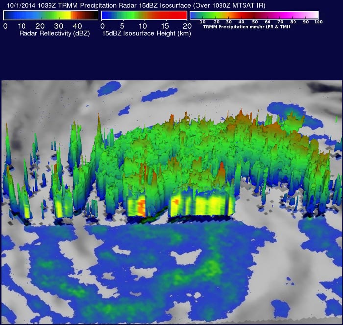
NASA’s TRMM satellite saw Phanfone was producing rainfall over a very large area on Oct. 1. Some storms in these bands were dropping rain at a rate of over 76 mm (almost 3 inches) per hour. Image Credit: SSAI/NASA, Hal Pierce
The TRMM satellite crossed above Typhoon Phanfone on October 1, 2014 at 1039 UTC and gathered data about rainfall rates occurring in the storm.
TRMM, or the Tropical Rainfall Measuring Mission satellite, is a managed by both NASA and the Japan Aerospace Exploration Agency and can peer into a storm and determine how light or heavy rain is falling.
At NASA’s Goddard Space Flight Center in Greenbelt, Maryland, rainfall data from TRMM's Microwave Imager (TMI) Precipitation Radar (PR) was used to create an image of the storm.
Typhoon Phanfone's winds were estimated to be above 65 knots (about 75 mph/120 kph) at the time TRMM passed over the storm. Winds within the increasingly powerful typhoon are expected to increase to over 100 kts (115 mph/185 kph) in the next few days while moving toward the islands of southern Japan.
This rainfall analysis revealed that Phanfone was producing rainfall over a very large area. The TRMM PR instrument indentified some storms in these bands were dropping rain at a rate of over 76 mm (almost 3 inches) per hour.
On Oct. 1 at 1500 UTC (11 a.m. EDT), Typhoon Phanfone had maximum sustained winds near 70 knots (80 mph/129 kph). It was centered near 19.3 north latitude and 140.9 east longitude, about 348 nautical miles (400 miles/644.5 km) south of the island of Iwo To, Japan. Phanfone is moving to the north-northwest at 10 knots (11.5 mph/18.5 kph).
The Joint Typhoon Warning Center forecasts Phanfone to continue moving in a northwesterly direction for the next couple of days before curving to the northeast where a landfall is expected in Japan by Oct. 6.
Hal Pierce
SSAI/NASA’s Goddard Space Flight Center
Media Contact
More Information:
http://www.nasa.gov/content/goddard/phanfone-northwestern-pacific-ocean/All latest news from the category: Earth Sciences
Earth Sciences (also referred to as Geosciences), which deals with basic issues surrounding our planet, plays a vital role in the area of energy and raw materials supply.
Earth Sciences comprises subjects such as geology, geography, geological informatics, paleontology, mineralogy, petrography, crystallography, geophysics, geodesy, glaciology, cartography, photogrammetry, meteorology and seismology, early-warning systems, earthquake research and polar research.


Newest articles

High-energy-density aqueous battery based on halogen multi-electron transfer
Traditional non-aqueous lithium-ion batteries have a high energy density, but their safety is compromised due to the flammable organic electrolytes they utilize. Aqueous batteries use water as the solvent for…

First-ever combined heart pump and pig kidney transplant
…gives new hope to patient with terminal illness. Surgeons at NYU Langone Health performed the first-ever combined mechanical heart pump and gene-edited pig kidney transplant surgery in a 54-year-old woman…

Biophysics: Testing how well biomarkers work
LMU researchers have developed a method to determine how reliably target proteins can be labeled using super-resolution fluorescence microscopy. Modern microscopy techniques make it possible to examine the inner workings…

