NASA sees hurricane-strength Tropical Cyclone Ita heading toward Queensland
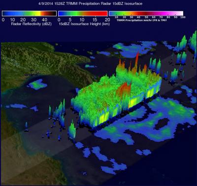
On April 9, NASA's TRMM saw powerful storms in Ita's eye wall reached heights of over 14 km/8.7 miles. The tallest thunderstorm towers reached heights of over 16 km/9.9 miles high in a feeder band well to the northeast of Ita's eye. Credit: NASA/SSAI, Hal Pierce
Ita's maximum sustained winds were near 115 knots/132 mph/213 kph on April 10 at 0900 UTV/5 a.m. EDT, making it a Category Four hurricane on the Saffir-Simpson scale. According to NOAA, the definition of a Category 4 storm affecting land is: “Catastrophic damage will occur: Well-built framed homes can sustain severe damage with loss of most of the roof structure and/or some exterior walls.
Most trees will be snapped or uprooted and power poles downed. Fallen trees and power poles will isolate residential areas. Power outages will last weeks to possibly months. Most of the area will be uninhabitable for weeks or months.”
Ita's center was still at sea, centered near 12.5 south and 147.1 east, about 275 nautical miles north-northeast of Cairns, Australia. Ita was moving to the north-northeast at 9 knots/10/3 mph/16.6 kph and generating 30-foot/9.1 meter high waves.
The Moderate Resolution Imaging Spectroradiometer or MODIS instrument aboard NASA's Terra satellite captured a visible image of Tropical Cyclone Ita approaching Australia on April 10 at 00:25 UTC. The image showed a cloud-shrouded eye with a thick band of powerful thunderstorms around the center of circulation.
On April 9, Ita was seen twice by NASA and the Japan Aerospace Exploration Agency's Tropical Rainfall Measuring Mission satellite known as TRMM satellite. Ita's wind speeds increased from 65 knots/75 mph with TRMM's first flight overhead at 0536 UTC/1:36 a.m. EDT to 80 knots/92 mph when viewed again at 1528 UTC/11:28 p.m. EDT.
TRMM's Microwave Imager (TMI) and Precipitation Radar (PR) instruments captured data on Tropical Cyclone Ita's rainfall at 1528 UTC/11:28 a.m. EDT. TRMM PR data showed that a maximum rainfall rate of almost 163 mm/6.4 inches per hour was located in the eastern side of Ita's eye wall.
TRMM's Precipitation Radar (PR) instrument sliced through Ita's eye and those data were used to create a 3-D “cut-a-way” view. The image showed that powerful storms in Ita's eye wall reached heights of over 14 km/8.7 miles. The tallest thunderstorm towers reached heights of over 16 km/9.9 miles high in a feeder band well to the northeast of Ita's eye.
Ita is continuing to intensify as it moves west, south of Papua New Guinea. The Joint Typhoon Warning Center or JTWC expects the system to peak at 135 knots/155 mph/250 kph on approach to Queensland. JTWC also expects the system will veer sharply southeast on approach to the Australian coastline, and gradually weaken as it passes along the eastern coastline of Queensland. Ita will commence extra-tropical transitioning north of Brisbane.
Current warnings in Queensland are in effect between Lockhart River and Innisfail, extending inland to Kalinga, Laura, Mareeba and Chillagoe. A tropical cyclone watch is in force between Innisfail to Cardwell, extending inland.
Media Contact
All latest news from the category: Earth Sciences
Earth Sciences (also referred to as Geosciences), which deals with basic issues surrounding our planet, plays a vital role in the area of energy and raw materials supply.
Earth Sciences comprises subjects such as geology, geography, geological informatics, paleontology, mineralogy, petrography, crystallography, geophysics, geodesy, glaciology, cartography, photogrammetry, meteorology and seismology, early-warning systems, earthquake research and polar research.


Newest articles

High-energy-density aqueous battery based on halogen multi-electron transfer
Traditional non-aqueous lithium-ion batteries have a high energy density, but their safety is compromised due to the flammable organic electrolytes they utilize. Aqueous batteries use water as the solvent for…

First-ever combined heart pump and pig kidney transplant
…gives new hope to patient with terminal illness. Surgeons at NYU Langone Health performed the first-ever combined mechanical heart pump and gene-edited pig kidney transplant surgery in a 54-year-old woman…

Biophysics: Testing how well biomarkers work
LMU researchers have developed a method to determine how reliably target proteins can be labeled using super-resolution fluorescence microscopy. Modern microscopy techniques make it possible to examine the inner workings…

