NASA Sees Heavy Rainfall as Cyclone Mahasen Made Landfall
When NASA’s TRMM satellite passed over Cyclone Mahasen on May 16 at 0406 UTC (12:04 a.m. EDT), the TRMM Microwave imager showed the heaviest rainfall was occurring in a band of thunderstorms north of the center of circulation. That band of thunderstorms was already over southern Bangladesh and dropping as much as 2 inches/50 mm of rain per hour along the coast. Credit: NASA/SSAI, Hal Pierce <br>
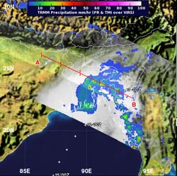
When NASA’s Tropical Rainfall Measuring Mission (TRMM) satellite passed over Cyclone Mahasen on May 16 at 0406 UTC (12:04 a.m. EDT), the TRMM Microwave imager showed the heaviest rainfall was occurring in a band of thunderstorms north of the center of circulation. That band of thunderstorms was already over southern Bangladesh and dropping as much as 2 inches/50 mm of rain per hour along the coast. TRMM measured the highest cloud tops near 7.4 miles / 12 km high.
Mahasen made landfall northwest of Chittagong around 0600 UTC (2 a.m. EDT) on May 16, as a tropical storm with maximum sustained winds near 45 knots (51.7 mph/83.3 kph). Mahasen is moving further inland in a north-northeasterly direction at 22 knots (25.3 mph/45.7 kph). At 0900 UTC (5 a.m. EDT), Mahasen was located near 23.7 north and 91.7 east, about 53 nautical miles (61 miles/98.1 km)southeast of Dhaka, Bangladesh. Just 50 minutes after TRMM captured the rainfall rates within Mahasen, the MODIS instrument aboard NASA’s Aqua satellite captured a visible image of Cyclone Mahasen that showed the extent of its clouds over India, Bangladesh, and Burma.
As of 12:38 UTC (8:38 a.m. EDT), the Bangladesh Meteorological Department (BMD) maintained a Signal Number 3 warning for maritime ports of Chittagong, Cox's Bazar and Mongla. For a look at Bangladesh radar, visit the BMD web page: http://tinyurl.com/c5vbs35.
The interaction with the land is causing Mahasen to fall apart rapidly, according to forecasters at the Joint Typhoon Warning Center. The system became disorganized just hours after it made landfall.
Mahasen is forecast to track across northeastern India while weakening, especially as it tracks over rugged terrain. Mahasen is also expected to encounter strong wind shear which will help speed the weakening and drop it below tropical storm status later in the day.
Text Credit: Rob Gutro
NASA's Goddard Space Flight Center, Greenbelt, Md.
Media Contact
All latest news from the category: Earth Sciences
Earth Sciences (also referred to as Geosciences), which deals with basic issues surrounding our planet, plays a vital role in the area of energy and raw materials supply.
Earth Sciences comprises subjects such as geology, geography, geological informatics, paleontology, mineralogy, petrography, crystallography, geophysics, geodesy, glaciology, cartography, photogrammetry, meteorology and seismology, early-warning systems, earthquake research and polar research.


Newest articles

High-energy-density aqueous battery based on halogen multi-electron transfer
Traditional non-aqueous lithium-ion batteries have a high energy density, but their safety is compromised due to the flammable organic electrolytes they utilize. Aqueous batteries use water as the solvent for…

First-ever combined heart pump and pig kidney transplant
…gives new hope to patient with terminal illness. Surgeons at NYU Langone Health performed the first-ever combined mechanical heart pump and gene-edited pig kidney transplant surgery in a 54-year-old woman…

Biophysics: Testing how well biomarkers work
LMU researchers have developed a method to determine how reliably target proteins can be labeled using super-resolution fluorescence microscopy. Modern microscopy techniques make it possible to examine the inner workings…

