NASA Sees Heaviest Rain North of Tropical Storm Flossie's Center
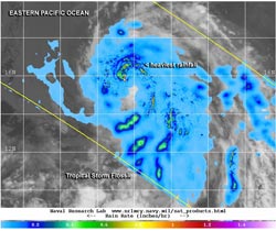
This image shows TRMM rainfall data laid over an infrared image from NOAA's GOES-15 satellite to show rainfall within Flossie's cloud cover. Heaviest rainfall (red) was falling north of the center. Image Credit: NRL/NASA/NOAA<br>
When NASA and the Japan Space Agency's Tropical Rainfall Measuring Mission or TRMM satellite passed over Tropical Storm Flossie, it measured rainfall rates occurring throughout the storm. TRMM noticed that the heaviest rainfall was occurring at a rate of 1.2 inches per hour north of the center. The heavy rain wrapped around the storm from the north to the east. Most of the remaining rainfall was light to moderate. Microwave satellite imagery shows some inner core features trying to form.
An image created at the Naval Research Laboratory, Washington, combined the TRMM data with an infrared image from NOAA's GOES-15 satellite to show rainfall within Flossie's cloud cover. Rain was falling throughout much of the storm.
On Friday, July 26 at 8 a.m. PDT (1500 UTC) the center of Tropical Storm Flossie was located near latitude 16.1 north and longitude 132.3 west, almost mid-way between the southern tip of Baja California and Hilo, Hawaii (about 1,530 miles (2, 465 km) from each place. Maximum sustained winds were near 50 mph (85 kph). Flossie was moving to the west-northwest at 18 mph (30 kph) and had a minimum central pressure of 1,000 millibars.
As Flossie continues its westward track, the National Hurricane Center notes that residents of Hawaii should monitor the storm's approach.
Text credit: Rob Gutro
NASA's Goddard Space Flight Center
Media Contact
More Information:
http://www.nasa.govAll latest news from the category: Earth Sciences
Earth Sciences (also referred to as Geosciences), which deals with basic issues surrounding our planet, plays a vital role in the area of energy and raw materials supply.
Earth Sciences comprises subjects such as geology, geography, geological informatics, paleontology, mineralogy, petrography, crystallography, geophysics, geodesy, glaciology, cartography, photogrammetry, meteorology and seismology, early-warning systems, earthquake research and polar research.


Newest articles

A universal framework for spatial biology
SpatialData is a freely accessible tool to unify and integrate data from different omics technologies accounting for spatial information, which can provide holistic insights into health and disease. Biological processes…

How complex biological processes arise
A $20 million grant from the U.S. National Science Foundation (NSF) will support the establishment and operation of the National Synthesis Center for Emergence in the Molecular and Cellular Sciences (NCEMS) at…

Airborne single-photon lidar system achieves high-resolution 3D imaging
Compact, low-power system opens doors for photon-efficient drone and satellite-based environmental monitoring and mapping. Researchers have developed a compact and lightweight single-photon airborne lidar system that can acquire high-resolution 3D…

