NASA sees former Typhoon Atsani's remnants affecting Alaska
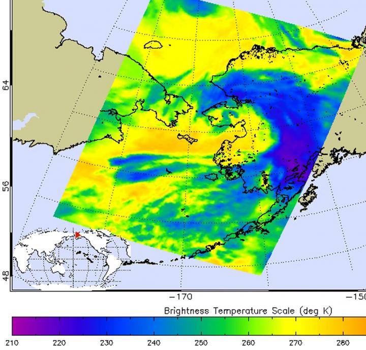
On Aug. 26 at 13:47 UTC, the AIRS instrument aboard NASA's Aqua satellite saw cloud tops in the remnants of Atsani as cold as -63F/-53C over central Alaska, indicating strong thunderstorms. Credits: NASA/JPL, Ed Olsen
Infrared data, such as that gathered by the Atmospheric Infrared Sounder (AIRS) instrument that flies aboard NASA's Aqua satellite is used to determine cloud top temperatures. The colder the cloud tops, the higher they are in the atmosphere, and they are usually stronger.
When Aqua passed over Alaska, the AIRS instrument gathered data on Atsani's remnant clouds. Cloud tops in the northern and eastern sides of the system were coldest near -63F/-53C, indicating strong storms with the potential for heavy rainfall. The infrared data was made into a false-colored image at NASA's Jet Propulsion Laboratory, Pasadena, California.
Fairbanks, located in the central part of the state has a wind advisory in effect from 6 pm this evening to 10 pm AKDT Thursday, August 27.
North of Fairbanks a winter storm watch is in effect as the precipitation is expected to fall in the form of snow. That watch covers areas above 2,000 feet in the Northeastern Brooks Range that includes Anaktuvuk Pass, Atigun Pass, Galbraith Lake, Sagwon and Franklin Bluffs. The Watch goes through Thursday evening, August 27 and calls for 3 to 6 inches of snow heaviest in Atigun Pass.
According to the National Weather Service office in Fairbanks, Alaska, between one and two inches of rain has fallen across much of the Northwest Brooks Range since Monday. The additional precipitation from Atsani's remnants triggered a flood advisory today, August 26, for the Northwestern Brooks Range until 2:30 a.m. local ADKT time, Thursday, August 27.
The National Weather Service (NWS) expects additional rainfall from one to two inches through Wednesday afternoon. The NWS noted that the heaviest rain will be on southwest facing slopes.
Media Contact
All latest news from the category: Earth Sciences
Earth Sciences (also referred to as Geosciences), which deals with basic issues surrounding our planet, plays a vital role in the area of energy and raw materials supply.
Earth Sciences comprises subjects such as geology, geography, geological informatics, paleontology, mineralogy, petrography, crystallography, geophysics, geodesy, glaciology, cartography, photogrammetry, meteorology and seismology, early-warning systems, earthquake research and polar research.


Newest articles

Microscopic basis of a new form of quantum magnetism
Not all magnets are the same. When we think of magnetism, we often think of magnets that stick to a refrigerator’s door. For these types of magnets, the electronic interactions…

An epigenome editing toolkit to dissect the mechanisms of gene regulation
A study from the Hackett group at EMBL Rome led to the development of a powerful epigenetic editing technology, which unlocks the ability to precisely program chromatin modifications. Understanding how…

NASA selects UF mission to better track the Earth’s water and ice
NASA has selected a team of University of Florida aerospace engineers to pursue a groundbreaking $12 million mission aimed at improving the way we track changes in Earth’s structures, such…

