NASA sees first Atlantic hurricane fizzling in cool waters
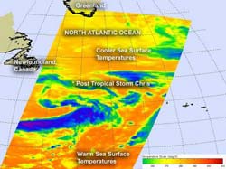
NASA's Aqua satellite passed over Post-Tropical Storm Chris on June 22 at 12:47 a.m. EDT. The infrared data from the AIRS instrument onboard Aqua indicated the storm is in waters that are too cool to maintain its strength. The waters are near 290 Kelvin (62F/16.8C). Credit: NASA/JPL, Ed Olsen<br>
Sea surface temperatures play a big role in keeping a tropical cyclone alive. They need warm seas of at least 300 Kelvin (80 Fahrenheit/26.8 Celsius) to maintain strength. NASA's Aqua satellite revealed that those conditions were not met where Chris is located in the Atlantic Ocean.
When NASA's Aqua satellite passed over Chris at 0447 UTC (12:47 a.m. EDT) today, June 22, the Atmospheric Infrared Sounder (AIRS) instrument captured a new infrared image of Chris' clouds and surrounding sea surface temperatures. The sea surface temperatures to the south of Chris are at least 300 Kelvin (80 Fahrenheit/26.8 Celsius) and warmer. In the area where Chris is located, AIRS revealed that sea surface temperatures are closer to 290 Kelvin (62 Fahrenheit/16.8 Celsius).
At 11 a.m. EDT on June 22, Chris was now classified as a post-tropical storm with maximum sustained winds near 45 mph (75 kmh). Chris was far to the north near 44.6 North and 46.9 West, about 335 miles (535 km) east-southeast of Cape Race, Newfoundland, Canada. Chris was moving to the west-southwest near 16 mph (kmh), and is expected to slow and turn southward. Chris' minimum central pressure is 990 millibars.
According to the National Hurricane Center, Chris “should merge with another extratropical low on Saturday [June 23]” in the north Atlantic Ocean.
Media Contact
More Information:
http://www.nasa.govAll latest news from the category: Earth Sciences
Earth Sciences (also referred to as Geosciences), which deals with basic issues surrounding our planet, plays a vital role in the area of energy and raw materials supply.
Earth Sciences comprises subjects such as geology, geography, geological informatics, paleontology, mineralogy, petrography, crystallography, geophysics, geodesy, glaciology, cartography, photogrammetry, meteorology and seismology, early-warning systems, earthquake research and polar research.


Newest articles

A universal framework for spatial biology
SpatialData is a freely accessible tool to unify and integrate data from different omics technologies accounting for spatial information, which can provide holistic insights into health and disease. Biological processes…

How complex biological processes arise
A $20 million grant from the U.S. National Science Foundation (NSF) will support the establishment and operation of the National Synthesis Center for Emergence in the Molecular and Cellular Sciences (NCEMS) at…

Airborne single-photon lidar system achieves high-resolution 3D imaging
Compact, low-power system opens doors for photon-efficient drone and satellite-based environmental monitoring and mapping. Researchers have developed a compact and lightweight single-photon airborne lidar system that can acquire high-resolution 3D…

