NASA sees a 14-mile-wide eye and powerful Super Typhoon Songda
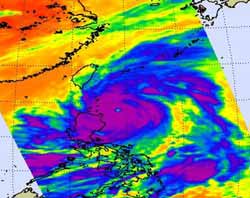
This infrared image of Super Typhoon Songda was captured by the AIRS instrument on NASA's Aqua satellite on May 27, 2011, at 5:05 UTC (1:05 a.m. EDT). At this time, Songda was a Category 4 storm. The purple areas indicate very strong thunderstorms with heavy rainfall and there is a large area of them that surround the visible eye. Taiwan is northwest of the storm. Credit: NASA/JPL, Ed Olsen<br>
The Atmospheric Infrared Sounder (AIRS) instrument on NASA's Aqua satellite captured an infrared image of Super Typhoon Songda on May 27, 2011 at 5:05 UTC (1:05 a.m. EDT). At that time Songda was a Category 4 storm. The infrared image showed a large area of very strong thunderstorms with heavy rainfall surrounding the eye of the storm. The eye is almost 14 miles (12 nm/22 km) in diameter and those thunderstorms were dropping rainfall as much as 2 inches (50 mm) per hour.
On May 27 at 1500 UTC (11 a.m. EDT), Typhoon Songda's maximum sustained winds were near 125 knots (143 mph/231 kmh) down from its peak of 140 knots (161 mph/260 kmh) which it reached late on May 26. Songda has tracked north-northwest but is expected to turn to the north-northeast.
AIRS infrared imagery from today shows that the cloud tops are warming, and convection (rapidly rising air that forms the thunderstorms that power a tropical cyclone) is weakening. The rule with infrared imagery and thunderstorms is: the colder the cloud top, the stronger the convection and stronger the thunderstorm. So, what's making Songda weaken? Cooler sea surface temperatures (now that its north of 20 degrees north latitude) and increasing southwesterly vertical wind shear.
Taiwan is already feeling the effects from Songda as the surf has kicked up and is expected to remain rough until Songda passes this weekend. Songda is currently expected to pass just to the east of Ishigakijima island and to the west of Kadena Air Base, putting the island on the strongest side (the northeastern corner) of the storm. Songda is then forecast by the Joint Typhoon Warning Center to continue moving northeast and curving past the east coast of Japan, while its center remains at sea. By May 30, Songda is expected to have passed Japan.
NASA's Hurricane page: www.nasa.gov/hurricane
Media Contact
More Information:
http://www.nasa.govAll latest news from the category: Earth Sciences
Earth Sciences (also referred to as Geosciences), which deals with basic issues surrounding our planet, plays a vital role in the area of energy and raw materials supply.
Earth Sciences comprises subjects such as geology, geography, geological informatics, paleontology, mineralogy, petrography, crystallography, geophysics, geodesy, glaciology, cartography, photogrammetry, meteorology and seismology, early-warning systems, earthquake research and polar research.


Newest articles

High-energy-density aqueous battery based on halogen multi-electron transfer
Traditional non-aqueous lithium-ion batteries have a high energy density, but their safety is compromised due to the flammable organic electrolytes they utilize. Aqueous batteries use water as the solvent for…

First-ever combined heart pump and pig kidney transplant
…gives new hope to patient with terminal illness. Surgeons at NYU Langone Health performed the first-ever combined mechanical heart pump and gene-edited pig kidney transplant surgery in a 54-year-old woman…

Biophysics: Testing how well biomarkers work
LMU researchers have developed a method to determine how reliably target proteins can be labeled using super-resolution fluorescence microscopy. Modern microscopy techniques make it possible to examine the inner workings…

