NASA Satellite Sees Several Western U.S. Fires Blazing
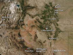
NASA's Aqua satellite picked up smoke (light brown) and hot spots (red) from fires in Colorado, Nevada, Arizona and New Mexico. This image was taken from the MODIS instrument onboard Aqua on June 19, 2012 at 2025 UTC (4:25 p.m. EDT). Credit: NASA Goddard MODIS Rapid Response Team, Jeff Schmaltz <br>
NASA's Aqua satellite captured smoke and heat signatures from several large fires burning in the western U.S. on June 19, 2012. When Aqua passed overhead, the Moderate Resolution Imaging Spectroradiometer (MODIS) instrument captured an image at 4:25 p.m. EDT.
MODIS infrared imaging can detect heat. Just as the infrared imagery from another instrument onboard Aqua, called the Atmospheric Infrared Sounder (AIRS) is used to detect temperature of clouds, land and sea surface, MODIS data can detect hot spots on land. In the MODIS images, fires, or hot spots are color coded as red areas in imagery and smoke appears in light brown. Images are generated at NASA's Goddard Space Flight Center in Greenbelt, Md.
As of June 22, Colorado's High Park Fire has burned 68,200 acres and has destroyed 189 homes, according to the U.S. Forest Service on the Inciweb. Inciweb is the Incident Inter-agency system, that tracks U.S. fire-related incidents, specifically wildland fires. The High Park Fire is located in the Roosevelt National Forest, about 15 miles west of Fort Collins, Colo. and was started by a lightning strike.
In southern Colorado, the Little Sand Fire is generating a thick plume of smoke in the Aqua satellite image. The fire is located 13 miles northwest of Pagosa Springs and has so far consumed 15,987 acres, according to Inciweb. Like the High Park Fire, it started from a lightning strike. It began on May 13 in the San Juan National Forest.
In Nevada, the North Schell Fire in the east central part of the state continues to burn and create a lot of smoke in the satellite imagery. According to the U.S. Forest Service on the Inciweb website, the North Schell Fire had consumed 11,987 acres on June 22, 2012. The fire began as a U.S. Forest Service prescribed burn on June 9. The area is managed by the Ely District of the U.S. Bureau of Land Management.
In Arizona, the Poco Fire in the Tonto National Forest appears to be creating the most smoke of the various wildfires burning in the state. The Poco Fire was human caused, and first reported on June 14, and is located northeast of Young, Ariz. By June 22, it had burned 11,950 acres, according to the U.S. Forest Service.
Smoke and the heat signatures from the Whitewater-Baldy Complex and Little Bear fires in New Mexico were also visible in the MODIS imagery from NASA's Aqua satellite.
In New Mexico, the Whitewater-Baldy complex fire has now consumed 296,980 acres, according to Inciweb. This is a fire that has generated a tremendous amount of smoke over the last several weeks.
The Little Bear fire is located in the Lincoln National Forest and had consumed 42, 980 acres as of June 22. According to the U.S. Forest Service, this fire was caused by lightning on June 4. Little Bear has destroyed 254 structures, and there are a number of area and road closures in effect. For more details, visit: http://www.inciweb.org/incident/2903/.
For the larger, unlabeled fire image, visit:
http://lance-modis.eosdis.nasa.gov/cgi-bin/imagery/single.cgi?image=UnitedStates.A2012171.2025.1km.jpg
Robert Gutro and information from Inciweb
NASA's Goddard Space Flight Center, Greenbelt, MD
Media Contact
All latest news from the category: Earth Sciences
Earth Sciences (also referred to as Geosciences), which deals with basic issues surrounding our planet, plays a vital role in the area of energy and raw materials supply.
Earth Sciences comprises subjects such as geology, geography, geological informatics, paleontology, mineralogy, petrography, crystallography, geophysics, geodesy, glaciology, cartography, photogrammetry, meteorology and seismology, early-warning systems, earthquake research and polar research.


Newest articles

A universal framework for spatial biology
SpatialData is a freely accessible tool to unify and integrate data from different omics technologies accounting for spatial information, which can provide holistic insights into health and disease. Biological processes…

How complex biological processes arise
A $20 million grant from the U.S. National Science Foundation (NSF) will support the establishment and operation of the National Synthesis Center for Emergence in the Molecular and Cellular Sciences (NCEMS) at…

Airborne single-photon lidar system achieves high-resolution 3D imaging
Compact, low-power system opens doors for photon-efficient drone and satellite-based environmental monitoring and mapping. Researchers have developed a compact and lightweight single-photon airborne lidar system that can acquire high-resolution 3D…

