NASA's RapidScat and Aqua satellite see Tropical Depression 9 developing
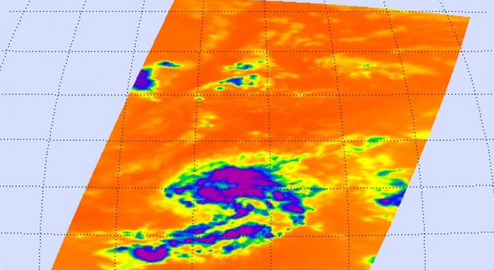
Infrared data from the AIRS instrument aboard NASA's Aqua satellite on Sept. 16 at 04:23 UTC (12:23 a.m. EDT) showed cold cloud tops of powerful thunderstorms wrapping north and east of TD9's center. Credits: NASA JPL, Ed Olsen
RapidScat data on September 15 at 10 a.m. EDT showed that the strongest sustained winds in the developing depression were north of the center near 24 meters per second (53.6 mph/ 86.4 kph).
Winds around the rest of the system were around 20 meters per second/72 km/44.7 mph, with the exception of the western quadrant, which were weaker. RapidScat wind data was analyzed by the RapidScat team at NASA's Jet Propulsion Laboratory, Pasadena, California.
Infrared data from the Atmospheric Infrared Sounder or AIRS instrument aboard NASA's Aqua satellite on Sept. 16 at 04:23 UTC (12:23 a.m. EDT) showed cold cloud tops of powerful thunderstorms wrapping north and east of the developing depression's center. Cloud top temperatures were as cold as -63F/-53C, and were capable of generating heavy rain.
At 11 a.m. (1500 UTC) on September 16 the center of Tropical Depression Nine was located near latitude 15.0 North, longitude 43.1 West. That puts the center about 1,270 miles (2,050 km) west of the Cape Verde Islands.
The depression is moving toward the north-northwest near 8 mph (13 kph). Maximum sustained winds are near 30 mph (45 kph) with higher gusts. The National Hurricane Center noted that little change in strength is forecast during the next 48 hours. The estimated minimum central pressure is 1010 millibars.
National Hurricane Center Forecaster Brennan noted that some southwesterly vertical wind shear is already affecting the cyclone, with most of the thunderstorms, clouds and convection (rising air that forms the thunderstorms that make up a tropical cyclone) pushed east and north of the estimated center position.
Brennan noted that the environment will becomes less favorable from this point forward, with the wind shear forecast to quickly increase over the next day and remain high through the remainder of the forecast period. In addition, the southwesterly flow aloft will bring dry mid- to upper-level air over the cyclone.
NHC expects Tropical Depression 9 to move in a north-northwestward to northwestward direction for the next couple of days and then turn west-northwest in four days.
Media Contact
All latest news from the category: Earth Sciences
Earth Sciences (also referred to as Geosciences), which deals with basic issues surrounding our planet, plays a vital role in the area of energy and raw materials supply.
Earth Sciences comprises subjects such as geology, geography, geological informatics, paleontology, mineralogy, petrography, crystallography, geophysics, geodesy, glaciology, cartography, photogrammetry, meteorology and seismology, early-warning systems, earthquake research and polar research.


Newest articles

High-energy-density aqueous battery based on halogen multi-electron transfer
Traditional non-aqueous lithium-ion batteries have a high energy density, but their safety is compromised due to the flammable organic electrolytes they utilize. Aqueous batteries use water as the solvent for…

First-ever combined heart pump and pig kidney transplant
…gives new hope to patient with terminal illness. Surgeons at NYU Langone Health performed the first-ever combined mechanical heart pump and gene-edited pig kidney transplant surgery in a 54-year-old woman…

Biophysics: Testing how well biomarkers work
LMU researchers have developed a method to determine how reliably target proteins can be labeled using super-resolution fluorescence microscopy. Modern microscopy techniques make it possible to examine the inner workings…

