NASA Eyes Typhoon Prapiroon Intensifying
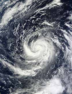
NASA's Terra satellite captured this visible image of Tropical Storm Prapiroon in the Philippine Sea on Oct. 8 at 0140 UTC. Credit: NASA Goddard MODIS Rapid Response Team<br>
Tropical Depression 22W was born on Oct. 7. On Monday, Oct. 8, the twenty-second tropical cyclone had organized and strengthened into Tropical storm Prapiroon. At that time it was located about 600 miles southeast of Kadena Air Base, Okinawa, Japan. The storm had maximum sustained winds near 55 knots (63.2 mph/102 kph) on Oct. 8.
The Moderate Resolution Imaging Spectroradiometer (MODIS) instrument aboard NASA's Terra satellite captured a visible image of Tropical Storm Prapiroon in the Philippine Sea on Oct. 8 at 0140 UTC. It revealed a large band of strong thunderstorms wrapping into the center from the west and south.
The next day, Oct. 9, Prapiroon had become a typhoon with maximum sustained winds near 65 knots (75 mph/120.4 kph). It is expected to continue intensifying over the next several days. Prapiroon was located near 18.0 North and 131.8 East longitude, about 555 nautical miles (639 miles/1,028 km) south-southeast of Kadena Air Base, Okinawa, Japan. It is moving to the west-northwest at 4 knots (4.6 mph/7.4 kph). Because the storm slowed down, it has intensified. NASA's Tropical Rainfall Measuring Mission satellite spotted an eye feature using microwave imagery.
Prapiroon is expected to continue moving west and then make a U-turn toward the northeast over the next day or two, while remaining over open ocean.
Text credit: Rob Gutro
NASA's Goddard Space Flight Center, Greenbelt, Md.
Media Contact
All latest news from the category: Earth Sciences
Earth Sciences (also referred to as Geosciences), which deals with basic issues surrounding our planet, plays a vital role in the area of energy and raw materials supply.
Earth Sciences comprises subjects such as geology, geography, geological informatics, paleontology, mineralogy, petrography, crystallography, geophysics, geodesy, glaciology, cartography, photogrammetry, meteorology and seismology, early-warning systems, earthquake research and polar research.


Newest articles

A universal framework for spatial biology
SpatialData is a freely accessible tool to unify and integrate data from different omics technologies accounting for spatial information, which can provide holistic insights into health and disease. Biological processes…

How complex biological processes arise
A $20 million grant from the U.S. National Science Foundation (NSF) will support the establishment and operation of the National Synthesis Center for Emergence in the Molecular and Cellular Sciences (NCEMS) at…

Airborne single-photon lidar system achieves high-resolution 3D imaging
Compact, low-power system opens doors for photon-efficient drone and satellite-based environmental monitoring and mapping. Researchers have developed a compact and lightweight single-photon airborne lidar system that can acquire high-resolution 3D…

