NASA eyes Typhoon Fanapi approaching Taiwan
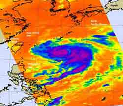
NASA\'s Aqua satellite passed over Typhoon Fanapi on Sept. 17 at 04:45 UTC (12:45 a.m. EDT) and captured this infrared image of its cold cloudtop temperatures. The coldest cloud tops were as cold as -60F, and the imagery showed a tight center circulation. Credit: NASA JPL, Ed Olsen<br>
At 1500 UTC (10 a.m. EDT) on Sept. 17, Typhoon Fanapi's maximum sustained winds were near 85 knots (97 mph). It was centered about 360 nautical miles east-southeast of Taipei, Taiwan near 23.2 North and 127.4 East. It is churning up high seas up to 22 feet.
NASA's Aqua satellite passed over Typhoon Fanapi on September 17 at 04:45 UTC (12:45 a.m. EDT) and captured an infrared image of its cold cloudtop temperatures. The coldest cloud tops were as cold as -60F, and the imagery showed a tight center circulation at that time.
Infrared imagery today continues to show Fanapi consolidating. The typhoon is on the border of becoming a Category 2 typhoon on the Saffir-Simpson hurricane/typhoon scale. Infrared imagery also showed that Fanapi has an 11 mile-wide eye, and that there's a small gap in the eyewall in the northern part of the circulation. Because vertical wind shear is expected to increase over the next 12 to 24 hours, Fanapi is expected to weaken at that time.
Another instrument on NASA's Aqua satellite captured a visible image of Typhoon Fanapi. To see the image that the Moderate Resolution Imaging Spectroradiometer (MODIS) instrument captured of Typhoon Fanapi on September 17 at 04:45 UTC, go to: http://rapidfire.sci.gsfc.nasa.gov/gallery/?2010260-0917/Fanapi.A2010260.0445.
Fanapi is now moving northwest at 6 mph and is expected to make landfall on Sept. 19 during the morning hours local Asia/Taipei time (late Sept. 18 EDT). Fanapi is forecast to cross Taiwan from east to west and then emerge into the Taiwan Strait as a tropical storm and make a final landfall in eastern China on Sept. 20.
Media Contact
More Information:
http://www.nasa.govAll latest news from the category: Earth Sciences
Earth Sciences (also referred to as Geosciences), which deals with basic issues surrounding our planet, plays a vital role in the area of energy and raw materials supply.
Earth Sciences comprises subjects such as geology, geography, geological informatics, paleontology, mineralogy, petrography, crystallography, geophysics, geodesy, glaciology, cartography, photogrammetry, meteorology and seismology, early-warning systems, earthquake research and polar research.


Newest articles

High-energy-density aqueous battery based on halogen multi-electron transfer
Traditional non-aqueous lithium-ion batteries have a high energy density, but their safety is compromised due to the flammable organic electrolytes they utilize. Aqueous batteries use water as the solvent for…

First-ever combined heart pump and pig kidney transplant
…gives new hope to patient with terminal illness. Surgeons at NYU Langone Health performed the first-ever combined mechanical heart pump and gene-edited pig kidney transplant surgery in a 54-year-old woman…

Biophysics: Testing how well biomarkers work
LMU researchers have developed a method to determine how reliably target proteins can be labeled using super-resolution fluorescence microscopy. Modern microscopy techniques make it possible to examine the inner workings…

