NASA eyes Tropical Cyclone Madi's rainfall
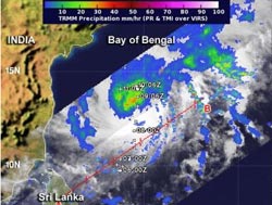
NASA's TRMM satellite captured data on Tropical Cyclone Madi's rainfall on Dec. 8 at 1144 UTC. The bulk of the rainfall was north of the center, and falling at a rate of 1 inch/30 mm per hour (green) with isolated areas of 2 inches/50 mm (red).<br><br>Credit: NASA/SSAI, Hal Pierce<br>
The Tropical Rainfall Measuring Mission satellite known as TRMM captured data on Tropical Cyclone Madi's rainfall on Dec. 8 at 1144 UTC/6:44 a.m. EST. TRMM saw the bulk of the storm's rainfall was occurring north of the center of circulation and falling at a rate of 1 inch/30 mm per hour with isolated areas of 2 inches/50 mm.
On December 9 at 1500 UTC/10 a.m. EST, Tropical Cyclone Madi's winds had weakened to near 60 knots/69 mph/111.1 kph. Madi had dropped from typhoon to tropical storm strength today, December 9. It was centered near 14.6 north latitude and 84.8 west longitude in the Northern Indian Ocean. Madi's center was about 280 nautical miles/322.2 miles/ 518.6 km east-northeast of Chennai, India, and the storm was still moving erratically, now to the north-northeast at 3 knots/3.4 mph/5.5 kph.
Forecasters at the Joint Typhoon Warning Center or JTWC now expect Madi to turn to the southwest and make landfall in southern India in Tamil Nadir on December 12. JTWC noted that Madi appears to have peaked in intensity and is forecast to weaken slowly through the period due to persistent vertical wind shear, dry air moving into the system and possible cooler sea surface temperatures associated with upwelling (water being drawn up from the bottom of the ocean as a result of being stirred by a tropical cyclone- which in this case is Madi itself, because it is moving so slowly).
The current track for the center of the cyclone brings it between the coastal city of Puducherry and the town of Mannarguddi, both along the southeastern coast.
Forecasters will be closely watching Madi as it moves across India as some forecast computer models suggest that its remnants could re-emerge into the Arabian Sea.
Media Contact
More Information:
http://www.nasa.govAll latest news from the category: Earth Sciences
Earth Sciences (also referred to as Geosciences), which deals with basic issues surrounding our planet, plays a vital role in the area of energy and raw materials supply.
Earth Sciences comprises subjects such as geology, geography, geological informatics, paleontology, mineralogy, petrography, crystallography, geophysics, geodesy, glaciology, cartography, photogrammetry, meteorology and seismology, early-warning systems, earthquake research and polar research.


Newest articles

A universal framework for spatial biology
SpatialData is a freely accessible tool to unify and integrate data from different omics technologies accounting for spatial information, which can provide holistic insights into health and disease. Biological processes…

How complex biological processes arise
A $20 million grant from the U.S. National Science Foundation (NSF) will support the establishment and operation of the National Synthesis Center for Emergence in the Molecular and Cellular Sciences (NCEMS) at…

Airborne single-photon lidar system achieves high-resolution 3D imaging
Compact, low-power system opens doors for photon-efficient drone and satellite-based environmental monitoring and mapping. Researchers have developed a compact and lightweight single-photon airborne lidar system that can acquire high-resolution 3D…

