NASA caught Soulik's visible eye before making deadly landfall
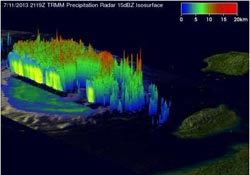
This TRMM Precipitation Radar 3-D view (from the northwest) shows Typhoon Soulik east of Taiwan. The structure of Soulik's large eye is clearly shown by this TRMM PR slice.<br><br>Credit: NASA/SSAI, Hal Pierce<br>
On July 11, when Typhoon Soulik was approaching Taiwan, NASA and the Japanese Space Agency's Tropical Rainfall Measuring Mission satellite known as TRMM passed overhead in space.
TRMM's Precipitation Radar instrument captured data on rainfall rates, and that data was used to create a 3-D view of the typhoon looking from the northwest. That 3-D view clearly showed Typhoon Soulik's eye when it was east of Taiwan. The 3-D image also revealed the ring of thunderstorms surrounding the eye had rainfall rates of 2 inches/50 mm per hour.
Two days later on July 13, Typhoon Soulik was a category one typhoon when NASA's Terra satellite flew over the storm. Terra's Moderate Resolution Imaging Spectroradiometer (MODIS) instrument captured another image of its eye. On July 13 at 0900 UTC (5 a.m. EDT), Soulik's maximum sustained winds were near 70 knots (80.5/129.6 kph). Those typhoon-strength winds extended 45 nautical miles (51.7 miles/83.3 km) from the center. At that time, Soulik's center had passed Taiwan and was 87 nautical miles (100 miles/161 km) west-northwest of Taipei, Taiwan, near 26.8 north and 120.1 east.
By 1500 UTC (11 a.m. EDT) on July 13, Soulik had made landfall near Fuzhou in southeastern China and was centered near 26.8 north and 119.1 east. After interacting with land, Soulik's maximum sustained winds fell to 60 knots (69 mph/111 kph).
According to the South China Morning Post, Soulik's flooding and landslides have left at least 300 people missing or dead. The southwestern province of Sichuan reported 68 deaths and 179 people missing. Two people died in the Guangdong province, and other parts of China reported 41 deaths and two missing.
Media Contact
More Information:
http://www.nasa.govAll latest news from the category: Earth Sciences
Earth Sciences (also referred to as Geosciences), which deals with basic issues surrounding our planet, plays a vital role in the area of energy and raw materials supply.
Earth Sciences comprises subjects such as geology, geography, geological informatics, paleontology, mineralogy, petrography, crystallography, geophysics, geodesy, glaciology, cartography, photogrammetry, meteorology and seismology, early-warning systems, earthquake research and polar research.


Newest articles

A universal framework for spatial biology
SpatialData is a freely accessible tool to unify and integrate data from different omics technologies accounting for spatial information, which can provide holistic insights into health and disease. Biological processes…

How complex biological processes arise
A $20 million grant from the U.S. National Science Foundation (NSF) will support the establishment and operation of the National Synthesis Center for Emergence in the Molecular and Cellular Sciences (NCEMS) at…

Airborne single-photon lidar system achieves high-resolution 3D imaging
Compact, low-power system opens doors for photon-efficient drone and satellite-based environmental monitoring and mapping. Researchers have developed a compact and lightweight single-photon airborne lidar system that can acquire high-resolution 3D…

