NASA Catches Short-lived Tropical Cyclone Hagibis Landfalling in China
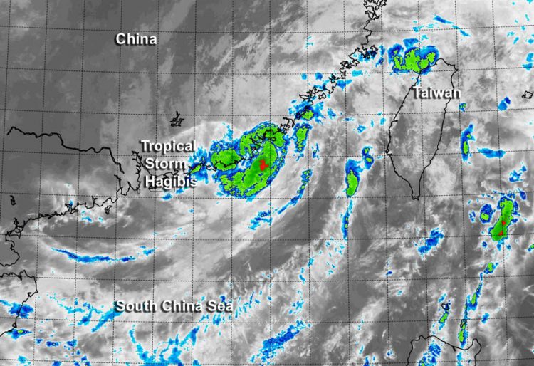
NASA's Terra satellite captured an infrared image at 14:15 UTC of Hagibis making landfall on the coast of Haojiang District of Shantou City in China's Guangdong Province. Image Credit: NRL/NASA
Hagibis was born in the South China Sea on June 14 at 0900 UTC (5 a.m. EDT) near 20.7 north latitude and 117.0 east longitude, about 183 nautical miles east-southeast of Hong Kong when a low pressure system quickly consolidated and maximum sustained winds jumped to 35 knots (40 mph/62 kph).
Hagibis is the seventh tropical depression of the Northwestern Pacific Ocean hurricane season. By the morning hours of June 15 Hagibis' maximum sustained winds peaked at 40 knots (46 mph/74 kph) as it neared China's coast.
As Hagibis was making landfall, NASA's Terra satellite passed overhead in its orbit around the Earth. The Moderate Resolution Imaging Spectroradiometer or MODIS instrument aboard Terra captured an infrared image at 14:15 UTC (12:15 p.m. EDT) that showed the storm making landfall on the coast of Haojiang District of Shantou City in China's Guangdong Province.
By 1500 UTC (11 a.m. EDT) on June 15, Hagibis was centered near 23.5 north latitude and 116.5 east longitude, about 146 nautical miles (168 miles/270.4 km) east-northeast of Hong Kong. Hagibis made landfall with maximum sustained winds near 35 knots (40 mph/62 kph).
Hagibis brought heavy rainfall to the Fujian and Guangdong provinces. According to a report from Xinhuanet, Hagibis dropped as much as 302 mm (11.8 inches) of rain in Guangdong province. Later in day, Hagibis dissipated over mainland China.
Text credit: Rob Gutro
NASA's Goddard Space Flight Center
Media Contact
More Information:
http://www.nasa.gov/content/goddard/hagibis-northwestern-pacific-ocean/All latest news from the category: Earth Sciences
Earth Sciences (also referred to as Geosciences), which deals with basic issues surrounding our planet, plays a vital role in the area of energy and raw materials supply.
Earth Sciences comprises subjects such as geology, geography, geological informatics, paleontology, mineralogy, petrography, crystallography, geophysics, geodesy, glaciology, cartography, photogrammetry, meteorology and seismology, early-warning systems, earthquake research and polar research.


Newest articles

A universal framework for spatial biology
SpatialData is a freely accessible tool to unify and integrate data from different omics technologies accounting for spatial information, which can provide holistic insights into health and disease. Biological processes…

How complex biological processes arise
A $20 million grant from the U.S. National Science Foundation (NSF) will support the establishment and operation of the National Synthesis Center for Emergence in the Molecular and Cellular Sciences (NCEMS) at…

Airborne single-photon lidar system achieves high-resolution 3D imaging
Compact, low-power system opens doors for photon-efficient drone and satellite-based environmental monitoring and mapping. Researchers have developed a compact and lightweight single-photon airborne lidar system that can acquire high-resolution 3D…

