NASA catches last image of Rafael as a hurricane, now merged with front
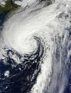
This visible image of Hurricane Rafael in the North Atlantic was taken from the MODIS instrument aboard NASA's Terra satellite on Oct. 17 at 1440 UTC (10:40 a.m. EDT). Rafael's northwestern fringe clouds were brushing Nova Scotia, Canada (top left).<br><br>Credit: NASA Goddard MODIS Rapid Response Team<br>
The Moderate Resolution Imaging Spectrometer (MODIS) instrument aboard NASA's Terra captured a visible image of Hurricane Rafael in the North Atlantic on Oct. 17 at 1440 UTC (10:40 a.m. EDT). Although Rafael was far from land, its northwestern fringe clouds were brushing Nova Scotia, Canada.
By 5 p.m. EDT on Oct. 17, Rafael had become extra-tropical, meaning that its core changed from a warm system to a cold system, just like a typical mid-latitude low pressure system. At that time, Rafael had maximum sustained winds near 75 mph (120 kph). It was centered near 40.2 North latitude and 56.5 West longitude, about 475 miles (750 km) southeast of Halifax, Nova Scotia, Canada. Rafael was moving to the northeast at 35 mph (56 kph). Turn toward the east-northeast with some increase in forward speed later today, Oct 18.
The National Hurricane Center noted that ocean swells generated by the cyclone are expected to affect the coast of eastern Canada during today and tomorrow. These swells are likely to cause life-threatening surf and rip currents.
By 5 p.m. EDT on Oct. 18, the cold front was found to be merged with the tropical cyclone, making it extra-tropical. Rafael is expected to complete a cyclonic loop around a deep-layer low over the north-central Atlantic day or two and ride into hurricane history.
Media Contact
More Information:
http://www.nasa.govAll latest news from the category: Earth Sciences
Earth Sciences (also referred to as Geosciences), which deals with basic issues surrounding our planet, plays a vital role in the area of energy and raw materials supply.
Earth Sciences comprises subjects such as geology, geography, geological informatics, paleontology, mineralogy, petrography, crystallography, geophysics, geodesy, glaciology, cartography, photogrammetry, meteorology and seismology, early-warning systems, earthquake research and polar research.


Newest articles

A universal framework for spatial biology
SpatialData is a freely accessible tool to unify and integrate data from different omics technologies accounting for spatial information, which can provide holistic insights into health and disease. Biological processes…

How complex biological processes arise
A $20 million grant from the U.S. National Science Foundation (NSF) will support the establishment and operation of the National Synthesis Center for Emergence in the Molecular and Cellular Sciences (NCEMS) at…

Airborne single-photon lidar system achieves high-resolution 3D imaging
Compact, low-power system opens doors for photon-efficient drone and satellite-based environmental monitoring and mapping. Researchers have developed a compact and lightweight single-photon airborne lidar system that can acquire high-resolution 3D…

