NASA catches last image of Rafael as a hurricane, now merged with front
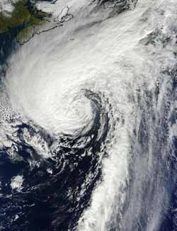
This visible image of Hurricane Rafael in the North Atlantic was taken from the MODIS instrument aboard NASA's Terra satellite on Oct. 17 at 1440 UTC (10:40 a.m. EDT). Rafael's northwestern fringe clouds were brushing Nova Scotia, Canada (top left).<br><br>Credit: NASA Goddard MODIS Rapid Response Team<br>
The Moderate Resolution Imaging Spectrometer (MODIS) instrument aboard NASA's Terra captured a visible image of Hurricane Rafael in the North Atlantic on Oct. 17 at 1440 UTC (10:40 a.m. EDT). Although Rafael was far from land, its northwestern fringe clouds were brushing Nova Scotia, Canada.
By 5 p.m. EDT on Oct. 17, Rafael had become extra-tropical, meaning that its core changed from a warm system to a cold system, just like a typical mid-latitude low pressure system. At that time, Rafael had maximum sustained winds near 75 mph (120 kph). It was centered near 40.2 North latitude and 56.5 West longitude, about 475 miles (750 km) southeast of Halifax, Nova Scotia, Canada. Rafael was moving to the northeast at 35 mph (56 kph). Turn toward the east-northeast with some increase in forward speed later today, Oct 18.
The National Hurricane Center noted that ocean swells generated by the cyclone are expected to affect the coast of eastern Canada during today and tomorrow. These swells are likely to cause life-threatening surf and rip currents.
By 5 p.m. EDT on Oct. 18, the cold front was found to be merged with the tropical cyclone, making it extra-tropical. Rafael is expected to complete a cyclonic loop around a deep-layer low over the north-central Atlantic day or two and ride into hurricane history.
Media Contact
More Information:
http://www.nasa.govAll latest news from the category: Earth Sciences
Earth Sciences (also referred to as Geosciences), which deals with basic issues surrounding our planet, plays a vital role in the area of energy and raw materials supply.
Earth Sciences comprises subjects such as geology, geography, geological informatics, paleontology, mineralogy, petrography, crystallography, geophysics, geodesy, glaciology, cartography, photogrammetry, meteorology and seismology, early-warning systems, earthquake research and polar research.


Newest articles

Recovering phosphorus from sewage sludge ash
Chemical and heat treatment of sewage sludge can recover phosphorus in a process that could help address the problem of diminishing supplies of phosphorus ores. Valuable supplies of phosphorus could…

Efficient, sustainable and cost-effective hybrid energy storage system for modern power grids
EU project HyFlow: Over three years of research, the consortium of the EU project HyFlow has successfully developed a highly efficient, sustainable, and cost-effective hybrid energy storage system (HESS) that…

After 25 years, researchers uncover genetic cause of rare neurological disease
Some families call it a trial of faith. Others just call it a curse. The progressive neurological disease known as spinocerebellar ataxia 4 (SCA4) is a rare condition, but its…

