NASA catches glimpse of the brief life of Southern Indian Ocean's first tropical cyclone
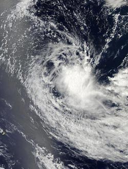
The MODIS instrument aboard NASA's Aqua satellite captured this visible image of Tropical Cyclone 01S in the South Indian Ocean. The image was taken on Oct. 27 at 09:30 UTC/4:30 a.m. EDT.<br><br>Credit: NASA Goddard MODIS Rapid Response Team<br>
The first tropical cyclone of the Southern Indian Ocean cyclone season formed on Oct. 27 near 13.1 south and 63.4 east, about 570 nautical miles northeast of Port Louis, Mauritus. It was moving to the west-southwest at 7 knots. Maximum sustained winds were near 35 knots.
On Oct. 27, satellite imagery showed that the low-level circulation center is elongated indicating the system was battling wind shear. Satellite imagery revealed that the strongest convection was around the southern edge of the center. Maximum sustained winds were near 35 knots/40 mph/64.8 kph and the storm was moving west.
The Moderate Resolution Imaging Spectroradiometer or MODIS instrument aboard NASA's Aqua satellite captured a visible image of Tropical Cyclone 01S in the South Indian Ocean. The image was taken on Oct. 27 at 09:30 UTC/4:30 a.m. EDT and showed an elongated storm.
On Oct. 28 at 0000 UTC/Oct. 27 at 8 p.m. EDT, Tropical Cyclone 01S was located near 13.1 south latitude and
62.5 east longitude, approximately 550 nautical miles north-northeast of La Reunion Island. Despite the maximum sustained winds near 35 knots/40 mph/64.8 kph, the storm was weakening and was expected to weaken because of wind shear.
Media Contact
More Information:
http://www.nasa.govAll latest news from the category: Earth Sciences
Earth Sciences (also referred to as Geosciences), which deals with basic issues surrounding our planet, plays a vital role in the area of energy and raw materials supply.
Earth Sciences comprises subjects such as geology, geography, geological informatics, paleontology, mineralogy, petrography, crystallography, geophysics, geodesy, glaciology, cartography, photogrammetry, meteorology and seismology, early-warning systems, earthquake research and polar research.


Newest articles

A universal framework for spatial biology
SpatialData is a freely accessible tool to unify and integrate data from different omics technologies accounting for spatial information, which can provide holistic insights into health and disease. Biological processes…

How complex biological processes arise
A $20 million grant from the U.S. National Science Foundation (NSF) will support the establishment and operation of the National Synthesis Center for Emergence in the Molecular and Cellular Sciences (NCEMS) at…

Airborne single-photon lidar system achieves high-resolution 3D imaging
Compact, low-power system opens doors for photon-efficient drone and satellite-based environmental monitoring and mapping. Researchers have developed a compact and lightweight single-photon airborne lidar system that can acquire high-resolution 3D…

