Extra-Tropical Storm Lekima Weakens in Northern Pacific
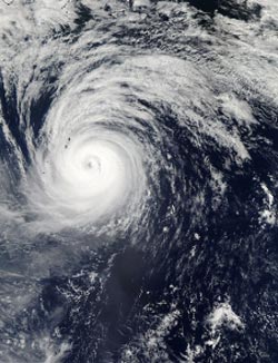
On Oct. 25 at 03:20 UTC, the MODIS instrument aboard NASA's Aqua satellite captured this visible image of Typhoon Lekima in the northwestern Pacific Ocean, the second to last day that it was at typhoon status before weakening. <br>Image Credit: NASA Goddard MODIS Rapid Response Team <br>
On Oct. 25 at 03:20 UTC, the Moderate Resolution Imaging Spectroradiometer or MODIS instrument aboard NASA's Aqua satellite captured a visible image of Typhoon Lekima in the northwestern Pacific Ocean.
It was the second to last day that Lekima held onto typhoon status before weakening to an extra-tropical storm. The image showed that Lekima still maintained an eye, although it was filling in with clouds. At the time of the MODIS image, bands of thunderstorms still wrapped tightly around the center of circulation.
On Saturday, Oct. 26 the Joint Typhoon Warning Center issued its final warning on Typhoon Lekima as it headed northeast into the cooler waters of the northern Pacific Ocean.
At 0900 UTC/5 a.m. EDT on Oct. 26, Lekima was still a typhoon with maximum sustained winds near 70 knots/80.5 mph/129.6 kph, but the winds were quickly waning. Lekima was located near 36.9 north latitude and 152.4 east longitude, about 565 nautical miles/650.2 miles/ 1.046 km east-southeast of Misawa, Japan. Lekima was transitioning into an extra-tropical, cold core low pressure area and speeding northeast at 39 knots/44.8 mph/72.2 kph.
As Lekima continued weakening the storm expanded. On Oct. 26 at 0900 UTC, tropical storm-force winds extended 210 nautical miles/241.7 miles/388.7 km from the center, making the storm as wide as 420 nautical miles/483.3 miles/777.7 km in diameter. Lekima was a weakening cold-core low pressure area on Oct. 28.
Text credit: Rob Gutro
NASA's Goddard Space Flight Center
Media Contact
All latest news from the category: Earth Sciences
Earth Sciences (also referred to as Geosciences), which deals with basic issues surrounding our planet, plays a vital role in the area of energy and raw materials supply.
Earth Sciences comprises subjects such as geology, geography, geological informatics, paleontology, mineralogy, petrography, crystallography, geophysics, geodesy, glaciology, cartography, photogrammetry, meteorology and seismology, early-warning systems, earthquake research and polar research.


Newest articles
Rocks with the oldest evidence yet of Earth’s magnetic field
The 3.7 billion-year-old rocks may extend the magnetic field’s age by 200 million years. Geologists at MIT and Oxford University have uncovered ancient rocks in Greenland that bear the oldest…

Decisive breakthrough for battery production
Storing and utilising energy with innovative sulphur-based cathodes. HU research team develops foundations for sustainable battery technology Electric vehicles and portable electronic devices such as laptops and mobile phones are…

Superradiant atoms could push the boundaries of how precisely time can be measured
Superradiant atoms can help us measure time more precisely than ever. In a new study, researchers from the University of Copenhagen present a new method for measuring the time interval,…

