NASA's TRMM satellite sees heavy rainfall in Tropical Storm Bud
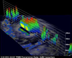
The TRMM satellite passed over Bud on May 22, 2012, at 6:43 p.m. EDT. This 3-D image from TRMM shows that some of the strong convective towers near Bud's center were taller than 15 km (~9.3 miles). Credit: NASA/TRMM, Hal Pierce<br>
The TRMM satellite had an excellent view of tropical storm Bud on May 22, 2012 at 2243 UTC 6:43 p.m. EDT/2:43 p.m. PDT). TRMM's Microwave Imager (TMI) and Precipitation Radar (PR) data shows that Bud contained bands of very heavy rainfall near the center of circulation. TRMM revealed that some of these intense storms were dropping rainfall at a rate greater than 50mm/hr (~2 inches).
A 3-D image from TRMM's PR shows that some of the strong convective towers near Bud's center were taller than 15km (~9.3 miles). TRMM PR found reflectivity values of over 58.050 dBz indicating that very heavy rainfall was occurring.
On May 23, at 1500 UTC (8 a.m. PDT) Tropical Storm Bud's maximum sustained winds were near 65 mph (100 kph). It was located near latitude 13.4 North and longitude 107.6 West, about 445 miles (715 km) south-southwest of Manzanillo, Mexico. Bud is headed northwest near 9 mph (15 kph) and is expected to slow down, according to the National Hurricane Center (NHC).
The NHC also forecasts that Bud will slow and turn to the north-northeast by Friday, May 25. NHC stated that Bud could become a hurricane later today (May 23) or tonight.
Media Contact
More Information:
http://www.nasa.govAll latest news from the category: Earth Sciences
Earth Sciences (also referred to as Geosciences), which deals with basic issues surrounding our planet, plays a vital role in the area of energy and raw materials supply.
Earth Sciences comprises subjects such as geology, geography, geological informatics, paleontology, mineralogy, petrography, crystallography, geophysics, geodesy, glaciology, cartography, photogrammetry, meteorology and seismology, early-warning systems, earthquake research and polar research.


Newest articles

A universal framework for spatial biology
SpatialData is a freely accessible tool to unify and integrate data from different omics technologies accounting for spatial information, which can provide holistic insights into health and disease. Biological processes…

How complex biological processes arise
A $20 million grant from the U.S. National Science Foundation (NSF) will support the establishment and operation of the National Synthesis Center for Emergence in the Molecular and Cellular Sciences (NCEMS) at…

Airborne single-photon lidar system achieves high-resolution 3D imaging
Compact, low-power system opens doors for photon-efficient drone and satellite-based environmental monitoring and mapping. Researchers have developed a compact and lightweight single-photon airborne lidar system that can acquire high-resolution 3D…

