3 NASA satellites see wide-eyed Cyclone Haruna
This false-colored infrared night-time image from NASA-NOAA's Suomi NPP satellite on Feb. 19 at 2303 UTC shows Cyclone Haruna's coldest cloud top temperatures (white) were north of the center.<br><br>Credit: NASA/NOAA/University of Wisconsin Madison<br>
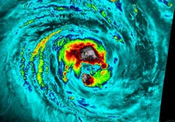
On Feb. 20 at 1111 UTC (6:11 a.m. EST/U.S.) the AIRS instrument aboard NASA's Aqua satellite captured this infrared image of Tropical Cyclone Storm Haruna. The area of strongest thunderstorms circled the eye and had cloud top temperatures colder than -63F (-52C). Those cold cloud top temperatures indicated strong storms with heavy rainfall, which was verified by NASA's Tropical Rainfall Measuring Mission (TRMM) satellite.
The Moderate Resolution Imaging Spectroradiometer (MODIS) instrument that flies with AIRS aboard NASA's Aqua satellite captured a visible image of Tropical Storm Haruna on Feb. 20 at 1115 UTC (6:15 a.m. EST) that revealed its large eye.
NASA's TRMM satellite flew above intensifying tropical storm Haruna on February 20, 2013 at 0717 UTC (2:17 a.m. EST). A rainfall analysis was created using data from TRMM's Microwave Imager (TMI) and Precipitation Radar (PR) instruments overlaid on a combination visible/infrared image from the Visible and InfraRed Scanner (VIRS). The analysis showed that Haruna had become much better organized since Feb. 19 and developed intense bands of rainfall circling the cyclone's center. Some rain in powerful storms on the northern edge of Haruna's center was found by TRMM PR to be falling at a rate of over 108 mm (~4.25 inches) per hour.
NASA's TRMM Precipitation Radar (PR) was used to create a 3-D image that sliced through tropical storm Haruna's center. TRMM data showed that towering thunderstorms on the northern edge of Haruna's center were over 14.25 km (~8.85 miles) high.
NASA-NOAA's Suomi NPP satellite captured infrared night-time data of Cyclone Haruna on Feb. 19 at 2303 UTC (2 a.m. local time Madagascar on Feb. 20). The data was false-colored at the University of Wisconsin Madison and showed the coldest cloud top temperatures and heaviest rainfall north of the center of circulation, verifying NASA's TRMM satellite data.
At 1500 UTC (10 a.m. EST) on Feb. 20, Haruna reached hurricane (or cyclone)-force with maximum sustained winds near 70 knots (80 mph/129.6 kph). Haruna is centered near 22.1 south latitude and 40.7 east longitude, about 400 nautical miles (460 miles/741 km) west-southwest of Antananarivo, Madagascar. Haruna is moving to the west at 4 knots (4.6 mph/7.4 kph) and generating 25-foot-high (7.6 meter-high) waves.
Forecasters at the Joint Typhoon Warning Center expect Haruna to make a brief landfall near Androka in the southwestern part of Madagascar as the storm heads southeast into the open waters of the southern Indian Ocean.
Media Contact
More Information:
http://www.nasa.govAll latest news from the category: Earth Sciences
Earth Sciences (also referred to as Geosciences), which deals with basic issues surrounding our planet, plays a vital role in the area of energy and raw materials supply.
Earth Sciences comprises subjects such as geology, geography, geological informatics, paleontology, mineralogy, petrography, crystallography, geophysics, geodesy, glaciology, cartography, photogrammetry, meteorology and seismology, early-warning systems, earthquake research and polar research.


Newest articles

Why getting in touch with our ‘gerbil brain’ could help machines listen better
Macquarie University researchers have debunked a 75-year-old theory about how humans determine where sounds are coming from, and it could unlock the secret to creating a next generation of more…

Attosecond core-level spectroscopy reveals real-time molecular dynamics
Chemical reactions are complex mechanisms. Many different dynamical processes are involved, affecting both the electrons and the nucleus of the present atoms. Very often the strongly coupled electron and nuclear…

Free-forming organelles help plants adapt to climate change
Scientists uncover how plants “see” shades of light, temperature. Plants’ ability to sense light and temperature, and their ability to adapt to climate change, hinges on free-forming structures in their…

