Tropical Depression Dokuri weaker, but still potent
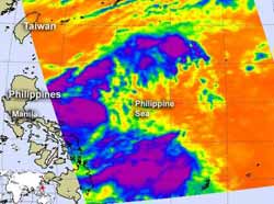
NASA's Aqua satellite passed over Tropical Storm Dokuri on June 27 on 0435 UTC (12:35 a.m. EDT). Infrared data from the AIRS instrument onboard, indicated the there were still some strong (purple) showers and thunderstorms within. Credit: Credit: NASA/JPL, Ed Olsen<br>
NASA's Aqua satellite passed over Tropical Storm Dokuri on June 27 on 0435 UTC (12:35 a.m. EDT). Infrared data from the Atmospheric Infrared Sounder (AIRS) instrument onboard indicated there were still some strong showers and thunderstorms within the system. Those cloud top temperatures were colder than -63 Fahrenheit (-52 Celsius), indicating strong uplift in the atmopshere, and thunderstorms within Dokuri that have the capability for heavy rainfall.
Infrared data shows a fully-exposed low level-circulation center. The strongest convection (rising air that creates thunderstorms that make up the system)are being pushed to the southwest due to strong northeasterly vertical wind shear.
Warnings are up in the Philippines as Doksuri (known there as Dindo) continues to move north of Luzon today. Public storm warning signal #1 is in effect in Abra, Kalinga, Isabela, Ilocos Sur, Mt. Province, Ifugao, La Union, Benguet, Pangasinan, Nueva Vizcaya and Quirino. Public storm warning signal #2 is also in effect for Cagayan, Calayan Group of Islands, Babuyan Group of Islands, Batanes Group of Islands, Apayao, Ilocos Norte.
On June 28, 2012 at 1500 UTC (11 a.m. EDT), Tropical Storm Doksuri had maximum sustained winds near 35 knots. It was located approximately 335 nautical miles north of Manila, Philippines, near 20.4 North and 120.7 East. It was moving to the west-northwestward at 17 knots. The strongest convection and thunderstorms were located over northern Luzon at this time, and are moving off the northwestern coast of the Philippines.
Doksuri has weakened as it passes to the north of Luzon. Doksuri is expected to continue tracking west and make landfall near Hong Kong in two days.
Media Contact
More Information:
http://www.nasa.govAll latest news from the category: Earth Sciences
Earth Sciences (also referred to as Geosciences), which deals with basic issues surrounding our planet, plays a vital role in the area of energy and raw materials supply.
Earth Sciences comprises subjects such as geology, geography, geological informatics, paleontology, mineralogy, petrography, crystallography, geophysics, geodesy, glaciology, cartography, photogrammetry, meteorology and seismology, early-warning systems, earthquake research and polar research.


Newest articles

Sea slugs inspire highly stretchable biomedical sensor
USC Viterbi School of Engineering researcher Hangbo Zhao presents findings on highly stretchable and customizable microneedles for application in fields including neuroscience, tissue engineering, and wearable bioelectronics. The revolution in…

Twisting and binding matter waves with photons in a cavity
Precisely measuring the energy states of individual atoms has been a historical challenge for physicists due to atomic recoil. When an atom interacts with a photon, the atom “recoils” in…

Nanotubes, nanoparticles, and antibodies detect tiny amounts of fentanyl
New sensor is six orders of magnitude more sensitive than the next best thing. A research team at Pitt led by Alexander Star, a chemistry professor in the Kenneth P. Dietrich…

