Satellite sees Tropical Storm Patricia form near Western Mexico coast
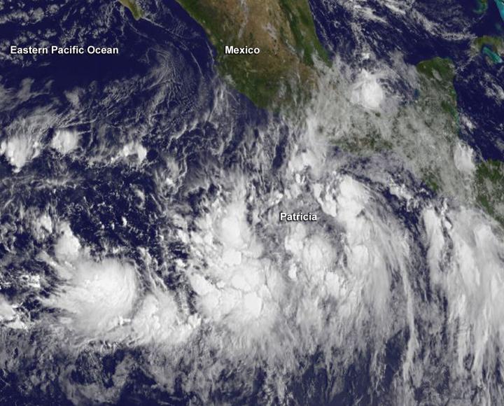
NOAA's GOES-West satellite captured this visible image of Tropical Storm Patricia near the southwestern coast of Mexico on Oct. 21, 2015, at 1500 UTC (11 a.m. EDT). Credits: NASA/NOAA GOES Project
An image of the tropical storm was captured by NOAA's GOES-West satellite that showed the storm near the coast. GOES-West is managed by NOAA, but the image was created by the NASA/NOAA GOES Project at the NASA Goddard Space Flight Center, Greenbelt, Maryland.
Visible and microwave satellite data showed that Patricia remains poorly organized at 11 a.m. EDT on October 21, 2015. The low-level circulation appeared elongated from north to south. According to the National Hurricane Center, convection (and the thunderstorm development and precipitation) is occurring mainly in an almost linear area west and south of the center.
A Hurricane Watch is in effect from Lazaro Cardenas to Playa Perula and a Tropical Storm Watch is in effect from east of Lazaro Cardenas to Tecpan De Galeana. Hurricane conditions are possible within the hurricane watch area by early Friday, October 23. Tropical storm conditions are possible within the watch areas by late Thursday or early Friday.
At 11 a.m. EDT (1500 UTC) on October 21, 2015 the center of Tropical Storm Patricia was located near latitude 12.9 degrees north and longitude 97.5 degrees west. That's about 320 miles (515 km) south-southeast of Acapulco, Mexico. Patricia was moving toward the west near 12 mph (19 kph) and is expected to turn toward the west-northwest at night, then to the northwest on October 22. On the forecast track, the center of Patricia should approach the coast of southwestern Mexico on Friday, October 23.
Maximum sustained winds are near 40 mph (65 kph) with higher gusts and strengthening is forecast during the next 48 hours. The National Hurricane Center expects Patricia to become a hurricane Thursday or Thursday night.
The National Hurricane Center noted that Patricia is expected to produce total rainfall accumulations of 6 to 12 inches, with isolated maximum amounts of 20 inches, over the Mexican states of Jalisco, Colima, Michoacan and Guerrero later Thursday into Saturday, October 24. These rains could produce life-threatening flash floods and mud slides.
For updated forecasts on Patricia, visit the National Hurricane Center website: http://www.
Media Contact
All latest news from the category: Earth Sciences
Earth Sciences (also referred to as Geosciences), which deals with basic issues surrounding our planet, plays a vital role in the area of energy and raw materials supply.
Earth Sciences comprises subjects such as geology, geography, geological informatics, paleontology, mineralogy, petrography, crystallography, geophysics, geodesy, glaciology, cartography, photogrammetry, meteorology and seismology, early-warning systems, earthquake research and polar research.


Newest articles

Webb captures top of iconic horsehead nebula in unprecedented detail
NASA’s James Webb Space Telescope has captured the sharpest infrared images to date of a zoomed-in portion of one of the most distinctive objects in our skies, the Horsehead Nebula….

Cost-effective, high-capacity, and cyclable lithium-ion battery cathodes
Charge-recharge cycling of lithium-superrich iron oxide, a cost-effective and high-capacity cathode for new-generation lithium-ion batteries, can be greatly improved by doping with readily available mineral elements. The energy capacity and…

Novel genetic plant regeneration approach
…without the application of phytohormones. Researchers develop a novel plant regeneration approach by modulating the expression of genes that control plant cell differentiation. For ages now, plants have been the…

