NASA tracks Typhoon Dolphin on approach to Iwo To
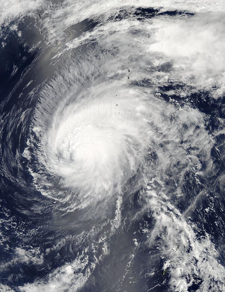
NASA's Aqua satellite captured this visible image of Typhoon Dolphin on May 18 at 04:00 UTC (12 a.m. EDT) on approach to Iwo To island, Japan. Credits: NASA Goddard MODIS Rapid Response
The MODIS instrument or Moderate Resolution Imaging Spectroradiometer instrument that flies aboard NASA's Aqua satellite passed over Typhoon Dolphin on May 18 at 04:00 UTC (12 a.m. EDT).
MODIS provided a visible look at the storm that showed southwesterly vertical wind shear was affecting the storm and pushing clouds and showers to the northeast of the center of circulation. Although the eye is not apparent in the MODIS visible imagery, microwave imagery did confirm that a ragged eye still existed today, May 18.
Dolphin is becoming embedded in the westerlies which are stretching the storm out. Westerlies are prevailing winds that blow from west to east (between 30 and 60 degrees latitude) in the middle latitudes.
At 1500 UTC (11 a.m. EDT), Typhoon Dolphin's maximum sustained winds were near 90 knots (103.6 mph/166.7 kph). It was centered 22.8 North latitude and 138.8 East longitude, about 203 nautical miles (233 miles/376 km) southwest of Iwo To, Japan. Dolphin was moving to the north-northeast at 8 knots (9.2 mph/14.8 kph).
Meteorologists at the Joint Typhoon Warning Center adjusted the forecast track and now take Dolphin west of Iwo To. That means that the strongest winds and heaviest rainfall, located on the northeastern side of the storm is more likely to affect the island as it passes by on May 19.
Dolphin is expected to maintain typhoon strength through May 19 and begin transitioning to an extra-tropical cyclone on May 20 when it weakens to tropical storm strength as a result of increased vertical wind shear and movement over cooler sea surface temperatures.
Media Contact
All latest news from the category: Earth Sciences
Earth Sciences (also referred to as Geosciences), which deals with basic issues surrounding our planet, plays a vital role in the area of energy and raw materials supply.
Earth Sciences comprises subjects such as geology, geography, geological informatics, paleontology, mineralogy, petrography, crystallography, geophysics, geodesy, glaciology, cartography, photogrammetry, meteorology and seismology, early-warning systems, earthquake research and polar research.


Newest articles

A universal framework for spatial biology
SpatialData is a freely accessible tool to unify and integrate data from different omics technologies accounting for spatial information, which can provide holistic insights into health and disease. Biological processes…

How complex biological processes arise
A $20 million grant from the U.S. National Science Foundation (NSF) will support the establishment and operation of the National Synthesis Center for Emergence in the Molecular and Cellular Sciences (NCEMS) at…

Airborne single-photon lidar system achieves high-resolution 3D imaging
Compact, low-power system opens doors for photon-efficient drone and satellite-based environmental monitoring and mapping. Researchers have developed a compact and lightweight single-photon airborne lidar system that can acquire high-resolution 3D…

