NASA spots Tropical Storm Jangmi moving into Sulu Sea
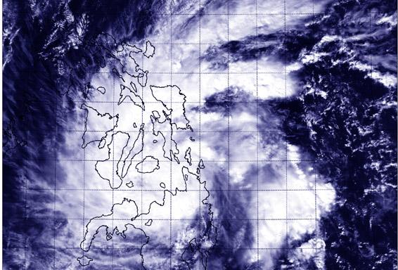
NASA's Aqua satellite captured this image of Tropical Storm Jangmi over the central and southern Philippines on Dec. 29 at 5:05 UTC. Image Credit: NASA/NRL
Many warnings remain in effect as Jangmi continues moving west toward the South China Sea. On Dec. 29, public storm warning signal #1 is in effect in the Visayas provinces of Leyte, Southern Leyte, Camotes Island, rest of Cebu, rest of Negros Occidental, Guimaras, southern part of Iloilo and southern part of Antique. The public storm warning #1 is also in effect in the Mindanao provinces of Bukidnon, Lanao del Norte and Sur, Misamis Occidental Zamboanga del Norte and Sur and Sibugay, Agusan del Sur.
The public storm warning signal #2 is in effect in the Visayas provinces of Bohol, Siquijor, Southern Cebu, Negros Oriental, Southern part of Negros Occidental. It is also in effect in the Mindanao provinces of Surigao del Norte, Siargao Island, Agusan del Norte, Misamis Oriental, Camiguin, and the Dinagat Province.
Tropical Storm Jangmi made landfall in northeastern Mindanao, Philippines on Dec. 28 and has moved across the central part of the country. NASA's Aqua satellite passed over Jangmi on Dec. 29 at 05:05 UTC (12:05 a.m. EST) and saw that the storm was over the Visayas (central) and Mindanao (southern) regions of the country. Bands of thunderstorms wrapped into the center from the northeastern and southeastern quadrants stretching back over the Philippine Sea (east of the country).
On Dec. 29 at 1500 UTC (10 a.m. EST), Jangmi had maximum sustained winds near 40 knots. It was moving to the northwest at 9 knots. Jangmi was centered near 10.0 north latitude and 124.2 east longitude, about 352 nautical miles southeast of Manila.
The Joint Typhoon Warning Center (JTWC) looked at animated enhanced infrared satellite imagery and a radar animation from Cebu Station, Philippines that showed Jangmi intensified as it tracked across the Surigao Strait. The low level circulation had become more tightly wrapped and better defined despite a weakening in the bands of thunderstorms as the system made landfall across Bohol Island.
JTWC's forecast on Dec. 29 calls for Jangmi to move in a west-southwesterly direction through the Sulu Sea and over southern Palawan before moving into the South China Sea while maintaining strength as a tropical storm. The current JTWC forecast track takes Jangmi toward the border of southern Thailand and northern Malaysia around January 3, 2015.
Rob Gutro
NASA's Goddard Space Flight Center
Media Contact
All latest news from the category: Earth Sciences
Earth Sciences (also referred to as Geosciences), which deals with basic issues surrounding our planet, plays a vital role in the area of energy and raw materials supply.
Earth Sciences comprises subjects such as geology, geography, geological informatics, paleontology, mineralogy, petrography, crystallography, geophysics, geodesy, glaciology, cartography, photogrammetry, meteorology and seismology, early-warning systems, earthquake research and polar research.


Newest articles

Webb captures top of iconic horsehead nebula in unprecedented detail
NASA’s James Webb Space Telescope has captured the sharpest infrared images to date of a zoomed-in portion of one of the most distinctive objects in our skies, the Horsehead Nebula….

Cost-effective, high-capacity, and cyclable lithium-ion battery cathodes
Charge-recharge cycling of lithium-superrich iron oxide, a cost-effective and high-capacity cathode for new-generation lithium-ion batteries, can be greatly improved by doping with readily available mineral elements. The energy capacity and…

Novel genetic plant regeneration approach
…without the application of phytohormones. Researchers develop a novel plant regeneration approach by modulating the expression of genes that control plant cell differentiation. For ages now, plants have been the…

