NASA Sees Wind Shear and Heavy Rainfall in Tropical Storm Philippe
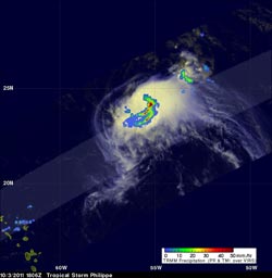
This TRMM image shows the heaviest rainfall in Philippe (2 inches/50 mm per hour) in red, falling in its southeastern quadrant. Moderate to light rainfall appears in green and blue, falling at a rate between .78 to 1.57 inches (20 to 40 mm) per hour. Credit: NASA/SSAI, Hal Pierce <br>
Philippe was still a tropical storm when the TRMM satellite passed above on October 3, 2011 at 1806 UTC (2:06 p.m. EDT) but the National Hurricane Center (NHC) predicts that the storm may become a hurricane in a couple days. TRMM's TMI and Precipitation Radar (PR) data showed that bands of powerful convective thunderstorms were still dropping rain at a rate of over 50mm/hr (~2 inches) in the southeastern quadrant of the storm because wind shear was pushing it there.
Philippe has been battling wind shear from the northwest, as the coldest cloud tops, heaviest rain and frequent lightning have remained on the southeastern side of the storm for the last two days.
At 11 a.m. EDT on Oct. 4, Tropical Storm Philippe's maximum sustained winds were still near 65 mph (as they were when TRMM flew overhead on Oct. 3). However, the National Hurricane Center noted that Philippe may still strengthen and reach hurricane status in the next couple of days. Philippe is still a small storm, about 170 miles in diameter, as tropical storm-force winds extend out 85 miles from the center.
Philippe's center was about 530 miles (850 km) south-southeast of Bermuda, near latitude 25.3 north and longitude 61.3 west. Philippe is moving toward the northwest near 6 mph (9 kmh), but is expected to speed up and turn to the northeast on Thursday, Oct. 6 because of a strong mid-latitude trough approaching it.
Text credit: Rob Gutro
NASA/Goddard Space Flight Center, Greenbelt, Md.
Media Contact
All latest news from the category: Earth Sciences
Earth Sciences (also referred to as Geosciences), which deals with basic issues surrounding our planet, plays a vital role in the area of energy and raw materials supply.
Earth Sciences comprises subjects such as geology, geography, geological informatics, paleontology, mineralogy, petrography, crystallography, geophysics, geodesy, glaciology, cartography, photogrammetry, meteorology and seismology, early-warning systems, earthquake research and polar research.


Newest articles

A universal framework for spatial biology
SpatialData is a freely accessible tool to unify and integrate data from different omics technologies accounting for spatial information, which can provide holistic insights into health and disease. Biological processes…

How complex biological processes arise
A $20 million grant from the U.S. National Science Foundation (NSF) will support the establishment and operation of the National Synthesis Center for Emergence in the Molecular and Cellular Sciences (NCEMS) at…

Airborne single-photon lidar system achieves high-resolution 3D imaging
Compact, low-power system opens doors for photon-efficient drone and satellite-based environmental monitoring and mapping. Researchers have developed a compact and lightweight single-photon airborne lidar system that can acquire high-resolution 3D…

