NASA Sees Tropical Storm 12S as a Threat to Madagascar
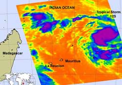
The AIRS instrument on NASA's Aqua satellite captured this infrared image of Tropical Storm 12S on February 9, 2012 at 09:41 UTC (4:41 a.m. EST). The strongest thunderstorms and heaviest rainfall are close to the center of circulation and in bands of thunderstorms to the south of the center, (purple) where cloud top temperatures are below -63 F (-52.7C). Credit: NASA/JPL, Ed Olsen<br>
Forecasters at the Joint Typhoon Warning Center expect a landfall in Madagascar in several days.
The Atmospheric Infrared Sounder (AIRS) instrument on NASA's Aqua satellite captured an infrared image of Tropical Storm 12S on February 9, 2012 at 09:41 UTC (4:41 a.m. EST) south of Diego Garcia.
Forecasters at the Joint Typhoon Warning Center noted that the system has consolidated quickly with improved convective banding (of thunderstorms) wrapping into the center.
The strongest thunderstorms and heaviest rainfall are close to the well-defined center of circulation and in bands of thunderstorms to the south of the center, where cloud top temperatures are below -63 F (-52.7C).
On February 9 at 1500 UTC (10 a.m. EST), Tropical Storm 12S (TS12S) had maximum sustained winds near 35 knots (40 mph/~65 kph). It was located 690 nautical miles (794 miles/1,278 km) northeast of La Reunion Island near 14.1 South latitude and 65.1 East longitude.
It was moving to the west near 9 knots (10.3 mph/16.7 kph) toward Madagascar. The forecasters at the Joint Typhoon Warning Center expect TS12S to strengthen as it moves west because of warm sea surface temperatures and light wind shear. Landfall at cyclone strength is expected in east central Madagascar sometime on February 13.
Text Credit: Rob Gutro
NASA's Goddard Space Flight Center, Greenbelt, Md.
Media Contact
All latest news from the category: Earth Sciences
Earth Sciences (also referred to as Geosciences), which deals with basic issues surrounding our planet, plays a vital role in the area of energy and raw materials supply.
Earth Sciences comprises subjects such as geology, geography, geological informatics, paleontology, mineralogy, petrography, crystallography, geophysics, geodesy, glaciology, cartography, photogrammetry, meteorology and seismology, early-warning systems, earthquake research and polar research.


Newest articles

A universal framework for spatial biology
SpatialData is a freely accessible tool to unify and integrate data from different omics technologies accounting for spatial information, which can provide holistic insights into health and disease. Biological processes…

How complex biological processes arise
A $20 million grant from the U.S. National Science Foundation (NSF) will support the establishment and operation of the National Synthesis Center for Emergence in the Molecular and Cellular Sciences (NCEMS) at…

Airborne single-photon lidar system achieves high-resolution 3D imaging
Compact, low-power system opens doors for photon-efficient drone and satellite-based environmental monitoring and mapping. Researchers have developed a compact and lightweight single-photon airborne lidar system that can acquire high-resolution 3D…

