NASA Sees the End of Post- Depression Fung-Wong
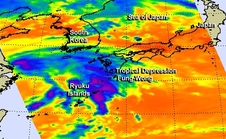
NASA's Aqua satellite passed over Tropical Depression Fung-Wong on Sept. 23 at 12:23 a.m. EDT and the storm resembled a frontal system more than a depression. Image Credit: NASA JPL, Ed Olsen
NASA's Aqua satellite passed over Tropical Depression Fung-Wong on Sept. 23 at 12:23 a.m. EDT.
The Atmospheric Infrared Sounder or AIRS instrument that flies aboard Aqua gathered infrared temperature data on the storm's clouds.
The data was false-colored at NASA's Jet Propulsion Laboratory, Pasadena, California and showed that the storm resembled a frontal system more than a depression.
The center of circulation was southwest of the bulk of thunderstorms and showers, which resembled a curved front. The strongest thunderstorms had cloud-top temperatures near -63F/-53C, and were over Japan's northern Ryuku Islands.
The Joint Typhoon Warning Center issued the final bulletin on Fung-Wong on Sept. 23 at 1500 UTC (11 a.m. EDT) when it was centered about 351 miles west of Sasebo, Japan, near 32.4 north latitude and 122.8 east longitude.
At the time, the depression had maximum sustained winds near 30 knots (34.5 mph/55.5 kph). It was moving to the northeast at 11 knots (12.6 mph/20.3 kph).
On Sept. 24, the remnants of Fung-Wong, now an extra-tropical storm continued moving to the northeast and into the tropical cyclone history books.
Rob Gutro
NASA's Goddard Space Flight Center
Media Contact
More Information:
http://www.nasa.gov/content/goddard/tropical-depression-16w-nw-pacific/All latest news from the category: Earth Sciences
Earth Sciences (also referred to as Geosciences), which deals with basic issues surrounding our planet, plays a vital role in the area of energy and raw materials supply.
Earth Sciences comprises subjects such as geology, geography, geological informatics, paleontology, mineralogy, petrography, crystallography, geophysics, geodesy, glaciology, cartography, photogrammetry, meteorology and seismology, early-warning systems, earthquake research and polar research.


Newest articles

A universal framework for spatial biology
SpatialData is a freely accessible tool to unify and integrate data from different omics technologies accounting for spatial information, which can provide holistic insights into health and disease. Biological processes…

How complex biological processes arise
A $20 million grant from the U.S. National Science Foundation (NSF) will support the establishment and operation of the National Synthesis Center for Emergence in the Molecular and Cellular Sciences (NCEMS) at…

Airborne single-photon lidar system achieves high-resolution 3D imaging
Compact, low-power system opens doors for photon-efficient drone and satellite-based environmental monitoring and mapping. Researchers have developed a compact and lightweight single-photon airborne lidar system that can acquire high-resolution 3D…

