NASA Sees Atlantic Depression Become Tropical Storm Lorenzo
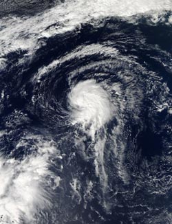
NASA's Aqua satellite captured this image of Tropical Depression 13L in the Atlantic on Oct. 21 at 16:55 UTC/12:55 p.m. EDT, before it became Tropical Storm Lorenzo. <br>Image Credit: NASA Goddard MODIS Rapid Response Team<br>
NASA's Aqua satellite captured a “before” image and NOAA's GOES satellite captured an “after” image of the depression's transition.
Lorenzo was born on Oct. 21 at 11 a.m. as Tropical Depression 13L. By 5 p.m. EDT it had strengthened into Tropical Storm Lorenzo. Lorenzo is also the twelfth tropical storm of the Atlantic Ocean Hurricane Season, which means that just one depression did not reach tropical storm strength so far this year.
The Moderate Resolution Imaging Spectroradiometer known as the MODIS instrument aboard NASA's Aqua satellite captured a visible image of Tropical Depression 13L in the Atlantic on Oct. 21 at 16:55 UTC/12:55 p.m. EDT before it became Tropical Storm Lorenzo. The visible image showed the bulk of the depressions thunderstorms and clouds were in the eastern and northern quadrants of the storm.
NOAA's GOES-East satellite captured a visible image of Tropical Storm Lorenzo on Oct. 22 at 1145 UTC/7:45 a.m. EDT as it continued strengthening in the central Atlantic Ocean. The GOES image showed that the bulk of clouds and showers had shifted to the north and west of the storm's center. In the GOES image, Lorenzo's strongest thunderstorms look almost like a horseshoe.
On Oct. 22 at 11 a.m. EDT/1500 UTC Lorenzo's maximum sustained winds had increased to near 50 mph/85 kph and the National Hurricane Center expects little change in strength, followed by a weakening trend on Oct. 23. Those tropical storm force winds extend outward up to 70 miles/110 km from Lorenzo's center.
Lorenzo's center was located far from land areas. It was near latitude 29.5 north and longitude 52.0 west, about 785 miles/1,260 km east of Bermuda. Lorenzo was moving toward the east-northeast near 8 mph/13 kph. The estimated minimum central pressure is 1003 millibars.
Forecasters at the National Hurricane Center (NHC) expect that Lorenzo is going to experience stronger wind shear from the northwest as it moves further northeast into cooler waters. Both of those factors are expected to take a toll on the storm and weaken it. By Oct. 25, Lorenzo is expected to become an elongated area of low pressure, a trough, ahead of an approaching cold front.
Text credit: Rob Gutro
NASA's Goddard Space Flight Center
Media Contact
All latest news from the category: Earth Sciences
Earth Sciences (also referred to as Geosciences), which deals with basic issues surrounding our planet, plays a vital role in the area of energy and raw materials supply.
Earth Sciences comprises subjects such as geology, geography, geological informatics, paleontology, mineralogy, petrography, crystallography, geophysics, geodesy, glaciology, cartography, photogrammetry, meteorology and seismology, early-warning systems, earthquake research and polar research.


Newest articles

Sea slugs inspire highly stretchable biomedical sensor
USC Viterbi School of Engineering researcher Hangbo Zhao presents findings on highly stretchable and customizable microneedles for application in fields including neuroscience, tissue engineering, and wearable bioelectronics. The revolution in…

Twisting and binding matter waves with photons in a cavity
Precisely measuring the energy states of individual atoms has been a historical challenge for physicists due to atomic recoil. When an atom interacts with a photon, the atom “recoils” in…

Nanotubes, nanoparticles, and antibodies detect tiny amounts of fentanyl
New sensor is six orders of magnitude more sensitive than the next best thing. A research team at Pitt led by Alexander Star, a chemistry professor in the Kenneth P. Dietrich…

